
Chatham Wave Buoy Captures 8-Foot Waves During Early June Storm
Published on: June 9, 2026
How big were the waves during last weekend’s storm?
Just ask the wave buoy.
Back in March, the Town of Chatham, Cape Cod Cooperative Extension, and partners deployed a wave buoy outside Chatham’s South Inlet to provide real-time information about ocean conditions. Since then, the buoy has been transmitting wave data every 30 minutes, giving boaters, fishermen, scientists, and coastal managers a detailed look at conditions offshore.
The system recently captured one of its largest wave events since deployment.
During the storm that ushered in June, significant wave heights climbed above 8 feet near the South Inlet. Data recorded by the buoy on May 30 showed waves reaching approximately 8.3 feet, with ocean swell exceeding 6.6 feet.
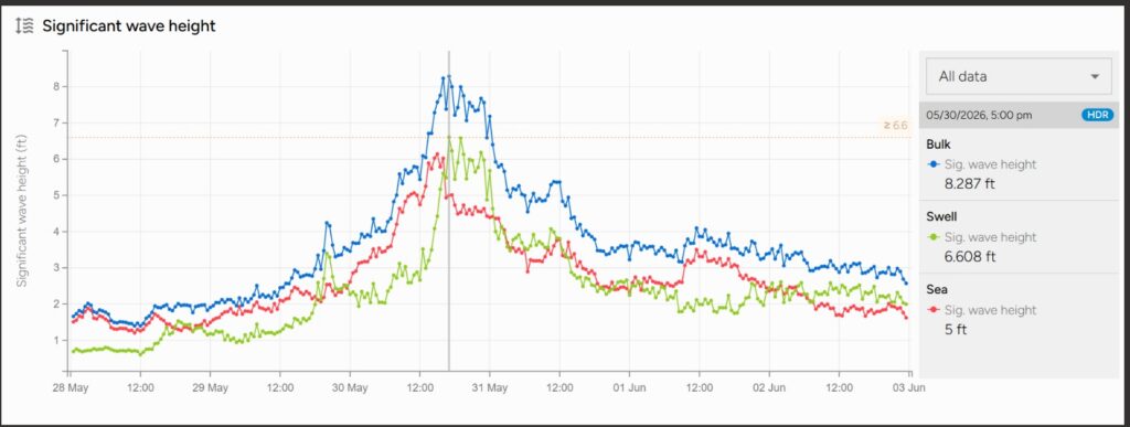
The wave buoy is part of an ongoing effort to improve understanding of local ocean conditions and provide publicly accessible information for people who work and recreate on the water.
“Over the last couple of months, we’ve gotten updates every half hour to help us keep track of exactly what’s going on offshore,” said Bryan McCormack, Coastal Processes Specialist with Cape Cod Cooperative Extension.
The information can be especially useful for:
- Commercial and recreational boaters
- Commercial and recreational fishermen
- Harbor and coastal managers
- Researchers and scientists
- Anyone interested in local ocean conditions
The buoy is located just outside Chatham’s South Inlet and reports conditions through the NERACOOS Mariners Dashboard.
Whether you’re planning a day on the water, tracking storm impacts, or simply curious about what’s happening offshore, the data is available to everyone.
View the live buoy data
https://mariners.neracoos.org/platform/SPOT-32785C
Cape Cod Cooperative Extension: Working for You
Follow Cape Cod Cooperative Extension on Facebook and Instagram for resources, updates, and events.
Learn more about all our programs at capecod.gov/extension.
Legal Disclaimer:
EIN Presswire provides this news content "as is" without warranty of any kind. We do not accept any responsibility or liability for the accuracy, content, images, videos, licenses, completeness, legality, or reliability of the information contained in this article. If you have any complaints or copyright issues related to this article, kindly contact the author above.
