
US 550 scheduled to fully close June 1 between Silverton and Molas Pass
Southwest Colorado - Beginning Monday, June 1, crews will perform four-day surface treatment operations on US Highway 550 from Molas Pass (MP 64) to approximately three miles north of Silverton (MP 73), near County Road 7. US 550 will be fully closed for one day, Monday, June 1 from 7 a.m. to 2 p.m. and then crews will transition to one-way alternating traffic for the next three days. Monday afternoon through Thursday afternoon motorists will encounter up to 15-minute delays, full stops and alternating traffic.
The one-day full-closure is required when crews are working along the high mountain pass corridor, south of Silverton, that is especially narrow with no shoulder area.
Motorists are urged to slow down and leave plenty of space between vehicles to avoid damage caused by loose stones and fresh paint striping.
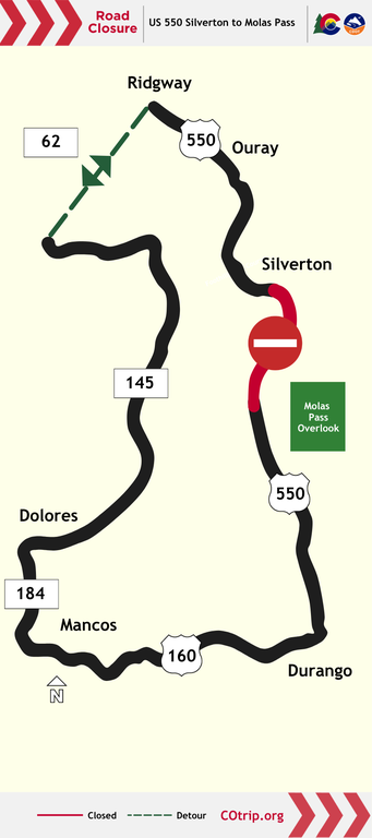
Drivers may consider an alternate route between Durango and Ridgway. This westerly route will add approximately one hour of additional driving time, taking approximately three hours from Durango to Telluride and ending in Ridgway (approximately 150 miles). Continuing south on US 550 to Silverton will add an additional 60 minutes of drive time (approximately 40 miles).
- US 160 Durango to Mancos
- CO 184 Mancos to Dolores
- CO 145 Dolores to Placerville
- CO 62 Placerville to Ridgway
- US 550 Ridgway to Silverton
Traffic Impacts
Working hours are planned from 7 a.m. to 2 p.m., on Monday, June 1. Traffic impacts include:
- Northbound Closure: Vehicles traveling northbound between Durango and Silverton will be stopped at Molas Pass (MP 64)
- Southbound Closure: Vehicles traveling southbound between Silverton and Durango will be stopped in the town of Silverton (MP 70)
Traffic impacts beginning Monday, June 1 at 2 p.m., after the full closure include:
- Motorists should plan for 10 to 15-minute delays and should allow for extra travel time
- Expect one-lane alternating traffic guided by a pilot vehicle
- Motorists entering the highway from a driveway or intersection must wait for a pilot car before proceeding with the flow of traffic
- A speed reduction of 40 MPH will be enforced through the work zone
Motorists are reminded to take the following precautions while traveling through the chip seal work zone.
- Slow down ― Higher speeds can cause loose stones to scatter and damage vehicle paint and windshields
- Increase distance between vehicles ― Space between you and other vehicles will help reduce damage caused by loose stones
- Follow work zone signage and flagging personnel ― Consider the safety of other motorists and the safety of the work crew when traveling through the project construction zone
- Use caution ― Cyclists and motorcyclists should use extreme caution along the recently treated highway segment
Know Before You Go
Travelers are urged to “know before you go.” Gather information about weather forecasts and anticipated travel impacts and current road conditions prior to hitting the road. CDOT resources include:
Remember: Slow For The Cone Zone
The following tips are to help you stay safe while traveling through maintenance and construction work zones.
- Do not speed in work zones. Obey the posted speed limits.
- Stay Alert! Expect the unexpected.
- Watch for workers. Drive with caution.
- Don't change lanes unnecessarily.
- Avoid using mobile devices such as phones while driving in work zones.
- Turn on headlights so that workers and other drivers can see you.
- Be especially alert at night while driving in work zones.
- Expect delays, especially during peak travel times.
- Allow ample space between you and the car in front of you.
- Anticipate lane shifts and merge when directed to do so.
- Be patient!
Download the COtrip App!
The new free COtrip Planner mobile app was designed to meet the growing trend of information on mobile and tablet devices for the traveling public. The COtrip Planner app provides statewide, real-time traffic information, and works on mobile devices that operate on the iOS and Android platforms. Visit the Google Play Store (Android devices) or the Apple Store (iOS devices) to download!
Legal Disclaimer:
EIN Presswire provides this news content "as is" without warranty of any kind. We do not accept any responsibility or liability for the accuracy, content, images, videos, licenses, completeness, legality, or reliability of the information contained in this article. If you have any complaints or copyright issues related to this article, kindly contact the author above.
