Imersion GIS Adds View In Map Feature to CountyPlatMaps.com
The only plat centric platform for searching, viewing and purchasing county plat maps in Texas.
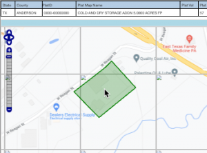
THE WOODLANDS, TX, USA, September 20, 2022 /EINPresswire.com/ -- Imersion GIS (IMGIS) added a “View in Map” feature to its plat aggregation platform – CountyPlatMaps.com.Searches for plats are available in Texas and Colorado by specific counties. A results grid shows matches where plat documents may be added to a cart for purchase and download. The new View in Map function generates a plat polygon over a google map where it can be viewed in relation to its surroundings in a street or satellite view.
“Viewing a plat polygon in a GIS map is our most requested feature. Our customers may now preview the location, description and satellite view all in one interface.” said Anil Adoni, Imersion GlS President.
“This is one of the many data sets and integrations available through Imersion GIS interfaces. We connected this to our CountyPlatMaps.com site to benefit our user base but also to illustrate the power of our GIS platform data.” added Joe Garcia, Imersion GIS Product.
Imersion GIS is committed to making county plat maps more accessible than ever. Creating an account, searching counties and viewing a plat polygon in a parcel are all available at no charge. Only pay for downloaded plat files.
In celebration, IMGIS is offering a promo code of VIEWMAP for a free plat map file download until 9/30/22.
About Imersion GlS
Imersion GIS is a leader in title industry focused GIS based solutions. IMGIS has various public and proprietary data sets in Texas and surrounding states. IMGIS enhances public data and creates correlations to consolidate sets into one platform. IMGIS offers API interfaces as well as white labeled solutions. IMGIS is headquartered in The Woodlands, TX with additional offices in the greater Hyderabad, India metro area. Please visit, Imersion GIS at www.imersiongis.com for a full list of services.
Anil Adoni
Imersion GIS
+1 281-782-6940
email us here
CountyPlatMaps.com View In Maps Feature
Legal Disclaimer:
EIN Presswire provides this news content "as is" without warranty of any kind. We do not accept any responsibility or liability for the accuracy, content, images, videos, licenses, completeness, legality, or reliability of the information contained in this article. If you have any complaints or copyright issues related to this article, kindly contact the author above.

