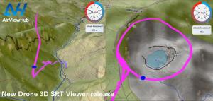
Visualize Drone Flight Data in 3D
Introducing the AirViewHub New 3D SRT Viewer (free)
SENDAI, MIYAGI, JAPAN, March 11, 2025 /EINPresswire.com/ -- We are excited to announce the official release of AirViewHub SRT Viewer, an innovative web application that brings 3D visualization to drone flight data. Unlike traditional 2D mapping solutions, this tool leverages altitude data from SRT files to accurately depict flight paths in three dimensions.Key Features of AirViewHub SRT Viewer (for DJI drone SRT file)
1️⃣ Realistic 3D Flight Path Visualization ✈️🌍
Our viewer processes latitude, longitude, and altitude data from SRT files (DJI drone) to create an intuitive 3D map of your drone’s flight path. Elevation changes, which were previously hard to discern in 2D, are now clearly visible for a more immersive experience.
2️⃣ No Software Installation Required 🌐⚡
Simply drag and drop your SRT file into a web browser on a PC or tablet—no downloads or installations needed. Get instant insights into your flight data with ease.
3️⃣ Multi-File Upload & Comparison 📂📌
Upload and analyze multiple flight data files simultaneously. Compare different flight sessions or examine variations in flight paths over different locations.
4️⃣ Free to Use 💸✨
Completely free for all users, from professional filmmakers to hobbyist drone pilots. Experience the full functionality without any cost.
Who Should Use AirViewHub SRT Viewer?
✅ Drone pilots seeking detailed flight path analysis
✅ Filmmakers and surveyors needing precise flight data
✅ Anyone wanting to visualize drone flights in an intuitive way
Try It Now!
🔗 Service URL: https://www.airviewhub.com/track
Example Aerial Videos Using AirViewHub SRT Viewer
🎥 Aerial Loop Around Zao Okama Volcano lake
🔗 https://www.youtube.com/watch?v=J7H_beeITSw
🎥 Banji Iwa Aerial Shot Along Futakuchi Gorge
🔗 https://www.youtube.com/watch?v=nd2L3mVF8XU
At AirViewHub, we are committed to enhancing usability and accessibility for drone users, enabling them to make better use of their flight data. We are continuously working on new features and improvements, and we welcome your feedback to help shape the future of our platform.
Contact Information:
AirVIewHub
Explore the World from the Skies with AirViewHub 🌍✈️
📧 Email: kino@airviewhub.com
🌍 Website: https://www3.airviewhub.com
Tadashi KINOSHITA
AirViewHub
kino@airviewhub.com
Visit us on social media:
Facebook
X
Instagram
YouTube
Other
3D-mapped drone flight path overlaid with aerial footage
Legal Disclaimer:
EIN Presswire provides this news content "as is" without warranty of any kind. We do not accept any responsibility or liability for the accuracy, content, images, videos, licenses, completeness, legality, or reliability of the information contained in this article. If you have any complaints or copyright issues related to this article, kindly contact the author above.

