Multinational Command and Control between Dissimilar Systems Is Possible
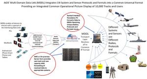
AGIS has an implemented and delivered solution to these incompatibilities, enabling multinational Command and Control.
Command and Control Issues – Some Examples
But there is a trend toward commonality of communication for some of these systems. This is especially true in the case of aircraft interoperability area where Link-16 is becoming the standard. To a lesser extent there is commonality for Ground C5ISR systems is also increasingly through use of the Joint Variable Message Formats (JVMF) compatible communications. Even then this has created a situation where the air Link-16 and ground JVMF equipped systems are unable to exchange even the basic information between each other, i.e. such as my location, my identity, and my speed and heading. This incompatibility issue is further complicated when sea system communications are added to the mix of communications. And yet even further complexed when non-Link-16 and JVMF air and ground systems are added to the to the mix of communications systems.
Sensor Issues – Some Examples
Command and Control systems are dependent on sensor inputs to have Situational Awareness. These reports can come from manually inputted data or real time sensors. Some typical Command and Control real time sensor feeds include radars, Electronic Intelligence (ELINT), Satellite data and other data sources. These are briefly discussed below:
Radars
There is no common standard for the data link formats that are used by different sensors even within a single country. As examples, the U.S. FAA radar CD-2 feeds are drastically different from feeds of the USMC’s new AN/TPS-80 G/ATOR radar. This is also the case with the Army’s Patriot radar and the Air Force’s radars. This lack of a common interface is not limited to the U.S. As an example, the Saudi AN/TPS -117 radars and their AN/TPS-43 radar use different data link formats.
ELINT
There is no common data link standard for interfacing U.S. ELINT systems. Neither is there a standard for fusing ELINT data with radar data.
Satellite Sensors
There is an increasing number of both military and commercial Weather, ELINT, SAR, and IMINT satellites providing real time sensor information. Again, there is no commonality between these satellite systems' data link formats.
Volume of Sensor Data
The amount of available sensor data has exploded beyond the current Air, Ground, and Sea systems’ C5ISR's capabilities to process. Where as many C5ISR system data links Link-16, JVMF, OTH Gold, AIS, CoT, NATO NFFI, ADEM, NVG and IBS data links are limited to less than 1,000 sensor returns 10,000 and more sensor reports are now available.
Symbology – Some Examples
Aircraft use the Link 16 symbols; Ground units Typically use MIL STD -2525 symbols and Naval units typically use Naval Tactical Data System (NTDS) symbols. These symbol sets are so radically different that a person knowledgeable in one is most of the time not knowledgeable in the others.
AGIS has an implemented and delivered solution to these incompatibilities, enabling International Command and Control.
AGIS command, control, computers, communications, cybersecurity, intelligence, surveillance, and reconnaissance (C5ISR) system resolves these issues by utilizing our Multi Domain Data Link (MDDL) Translator processing software which converts each of the interfacing C5ISR systems data and received sensor data into a common MDDL format.
The MDDL Server stores the data in its database and appropriately sends the data back to the MDDL Translator, which converts the data into the format required by the interfacing Air, Ground and Sea Interfacing C5ISR systems. Thus, each system can receive and process the information transmitted by the other interfacing systems.
Since each C5ISR system receives the data, it is able to process from the other C5ISRs and from their sensors, and a basic synchronized Multi Service, Multi-National Common Operational Picture (COP) is established between the interfacing C5ISR systems.
AGIS’ MDDL System accommodates Harris and other radios, MANETS, Satellite radios, 5G cellular and other communications. The Internet Protocol (IP) enables the AGIS’ MDDL System to handle 10,000s of real time sensor reports which the Defense Information Systems Agency (DISA) asked us to demonstrate both with a video and with real time interaction with the sensors which we did. VIDEO: https://zadar.us/disa/tem/video/TEM-2021-10-05-Advanced-Ground-Information-Systems-MDDL-C4ISR-System.mp4
The AGIS Display operators have full C5ISR Operator capabilities including the capability to send Engage commands. For Ground Forces, they can designate targets with the Advanced Field Artillery Tactical Data System (AFATDS) or use a Laser target designator to accomplish the same task. For the Maritime Forces, this includes the ability to designate hostile targets using OTH Gold or Link 16. For the Air Forces, this includes being able to designate hostile targets using Link 16.
To facilitate communications with other C5ISR systems AGIS MDDL System permits operators to shift between symbol types including MIL STD -2525 and NTDS.
To facilitate operations using a common system between different Nations, AGIS MDDL system’s operator display controls can be selected to use different languages. These currently include English, Ukrainian and Portuguese.
AGIS is a world leader in providing interoperability among C5ISR systems that employ differing formats, types and modes of digital communication. For missions that require international or cross-domain collaboration and teamwork, AGIS MDDL software delivers with the lightest footprint and ease of use.
AGIS’ MDDL system is comparatively very low cost and is available for U.S. customers either directly or through GSA Contract #47QTCA22D000R. It is also available to NATO, Partnership for Peace and other allied countries.
George K Barros
Advanced Ground Information Systems (AGIS)
gbarros@agisinc.com
Defense Information Systems Agency (DISA) Video TEM
Legal Disclaimer:
EIN Presswire provides this news content "as is" without warranty of any kind. We do not accept any responsibility or liability for the accuracy, content, images, videos, licenses, completeness, legality, or reliability of the information contained in this article. If you have any complaints or copyright issues related to this article, kindly contact the author above.

