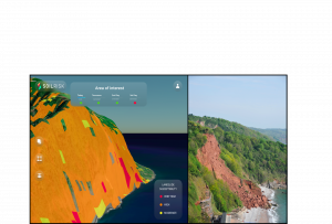
SOILRISK is a New Application for Predicting Landslide Hazards to Save Lives
SOILRISK uses machine learning and AI to predict and issue warnings about landslides
ANGRA DO HEROISMO, PORTUGAL , June 21, 2021 /EINPresswire.com/ -- Eyecon Group, a company specializing in remote sensing applications using machine learning and artificial intelligence, is proud to announce the launch of its new SOILRISK application. SOILRISK is a predictive model application for landslide hazards.Landslides account for an average of 25 to 50 deaths in the United States annually and thousands of deaths worldwide every year.
“It is scientifically proven that global warming is increasing the occurrence of extreme meteorological events, such as an intensification of rainfall episodes, that have a direct impact on the severity of landslides,” said Eyecon Group CEO Miguel Correia. “Within this context, the systematic monitoring of
landslides is vital to prevent and mitigate the consequences they might have. For this reason, we created and present SOILRISK, a high-resolution predictive model application for landslides that gathers atmospheric and environmental data and converts it into valuable intelligence to forecast landslide
occurrence and provide a warning system for prevention.”
SOILRISK is built with the most advanced predictive landslide algorithm. It provides a detailed picture of the conditions for a potential landslide event, making it an asset for on-time prediction to save lives. The algorithm was tested successfully in the Azores region, but thanks to open-source data as its basic element, it is ready to be applied globally.
SOILRISK uses a machine learning approach, as well as a proprietary early-warning algorithm. More than 20 conditioning factors are analyzed, including land, cover, lithology, vegetation, moisture, wind speed, precipitation and subsidence, to monitor large and small areas systematically. SOILRISK can also
be used for slope and infrastructure deformation monitoring.
SOILRISK is available on a pay-per-use or subscription basis and has an easily integrated API and 3D web-based GIS. The high-accuracy, predictive model is the most complete decision tree to date and offers user and area of interest-configurable alerts. SOILRISK is currently available in the United States,
Canada, Brazil, Central and Latin America, Portugal, Spain, Australia and New Zealand. The tool provides invaluable resources and emergency warnings for emergency management bodies at the county, state and federal levels; civil protection entities; infrastructure risk managers; insurance companies;
construction and real estate companies; and more.
For more information on SOILRISK, visit soilrisk.com.
END
###
Media Relations
Eyecon Group
email us here
Legal Disclaimer:
EIN Presswire provides this news content "as is" without warranty of any kind. We do not accept any responsibility or liability for the accuracy, content, images, videos, licenses, completeness, legality, or reliability of the information contained in this article. If you have any complaints or copyright issues related to this article, kindly contact the author above.

