TORONTO, Oct. 09, 2019 (GLOBE NEWSWIRE) -- Xanadu Mines Ltd (ASX: XAM, TSX: XAM) (“Xanadu” or “the Company”) is pleased to advise that recent diamond drilling has intersected wide zones of strong oxide gold mineralisation above the current Mineral Resource at the Copper Hill deposit at its flagship Kharmagtai Project in southern Mongolia (Figures 1 and 2).
HIGHLIGHTS
Four shallow drill holes completed at Copper Hill
All drill holes intersect significant oxide gold mineralisation
Significant results returned include:
- KHDDH520 returned 61m @ 1.08g/t Au from 9m
including 23m @ 2.37g/t Au from 47m
- KHDDH523 returned 47m @ 2.39g/t Au from 28m
including 35m @ 3.04g/t Au from 40m
including 20m @ 4.69g/t Au from 55m
Results are very encouraging and demonstrate excellent potential for a shallow oxide resource
Xanadu’s Chief Executive Officer, Dr Andrew Stewart, said“We are very pleased by the first drill results from the oxide zone at Copper Hill. What encourages us most by what we see at Stockwork Hill, Golden Eagle and now Copper Hill is the grade and potential scale and strike extent of the oxide system. While further drilling is required across the resource as the project advances, these new intersections of significant widths of shallow oxide mineralisation highlight the potential and show that we have just scratched the surface in terms of the broader resource potential. Further, it represents the opportunity for a low cost, high-value gold gravity and leach operation which could be run early in the development life of Kharmagtai, injecting significant cash into the project to offset the cost of developing a large-scale copper-gold mine.
Given Kharmagtai sits on a granted mining lease with a registered water resource and an established power supply nearby, we have the ability to move quickly on an oxide gold project, and our current strategy of seeking high-return options via an oxide gold project is focused on providing the capital needed to advance that larger scale copper and gold project.”
SIGNIFICANT RESULTS AT COPPER HILL
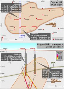
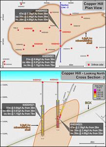
A four-hole program has been completed at Copper Hill to expand the gold-rich core and confirm continuity of oxide gold mineralisation (Figure 3, 4 & 5). Previous drilling at Copper Hill was offset from potential shallow mineralisation as explorers targeted deeper sulphide. As such the oxide and transitional gold potential of the deposit is yet to be assessed. Holes are vertical PQ drill holes with 25m spacing. The objective of this drilling was to identify, expand this oxide mineralisation, test continuity and gain an understanding of the oxide-transitional zone mineralogy and distribution so that accurate metallurgy can be obtained.
The following drill results have been returned for all the four holes.
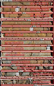
KHDDH520 returned 61m @ 1.08g/t Au from 9m
including 23m @ 2.37g/t Au from 47m
KHDDH521 returned 51m @ 0.64g/t Au from 38m
including 8m @ 1.15g/t Au from 78m
KHDDH522 returned 53m @ 1.04g/t Au from 12m
including 31m @ 1.43g/t Au from 34m
including 17m @ 1.94g/t Au from 48m
KHDDH523 returned 47m @ 2.39g/t Au from 28m
including 35m @ 3.04g/t Au from 40m
including 20m @ 4.69g/t Au from 55m
Tables 1 and 2 contain the full intercepts and drill hole locations and Figures 3 and 4 provide drill plans and sections.
ABOUT COPPER HILL OXIDE GOLD
Copper Hill consists of the highest-grade zone of copper-gold mineralisation at Kharmagtai where very high-density vein hosted sulphide mineralisation occurs over a 200m by 100m pod that plunges to approximately 300m in depth. Near surface mineralisation at Copper Hill has been largely undrilled as previous drilling is stepped back from the surface to target the deeper sulphide. This has left an opportunity for oxide and transitional gold un-tested. As this material will need to be mined during open pitting of Copper Hill and the oxide gold potential must be tested. The current drill program confirms the presence of both oxide and transitional gold. The next steps will be to conduct metallurgy to assess the viability of gravity separation versus leaching.
Photos accompanying this announcement are available at
The information in this announcement that relates to exploration results is based on information compiled by Dr Andrew Stewart, who is responsible for the exploration data, comments on exploration target sizes, QA/QC and geological interpretation and information. Dr Stewart, who is an employee of Xanadu and is a Member of the Australasian Institute of Geoscientists, has sufficient experience relevant to the style of mineralisation and type of deposit under consideration and to the activity he is undertaking, to qualify as the “Competent Person” as defined in the 2012 Edition of the “Australasian Code for Reporting Exploration Results, Mineral Resources and Ore Reserves” and the National Instrument 43-101. Dr Stewart consents to the inclusion in the report of the matters based on this information in the form and context in which it appears.
Table 1: Currently returned assay intercepts for Copper Hill
Set out below is Section 1 and Section 2 of Table 1 under the JORC Code, 2012 Edition for the Kharmagtai project. Data provided by Xanadu. This Table 1 updates the JORC Table 1 disclosure dated 31 July 2019.
1.1JORC TABLE 1 - SECTION 1 - SAMPLING TECHNIQUES AND DATA
Criteria
JORC Code explanation
Commentary
Sampling techniques
Nature and quality of sampling (e.g. cut channels, random chips, or specific specialised industry standard measurement tools appropriate to the minerals under investigation, such as down hole gamma sondes, or handheld XRF instruments, etc.). These examples should not be taken as limiting the broad meaning of sampling.
Include reference to measures taken to ensure sample representivity and the appropriate calibration of any measurement tools or systems used.
Aspects of the determination of mineralisation that are Material to the Public Report.
In cases where ‘industry standard’ work has been done this would be relatively simple (e.g. ‘reverse circulation drilling was used to obtain 1 m samples from which 3 kg was pulverised to produce a 30 g charge for fire assay’). In other cases, more explanation may be required, such as where there is coarse gold that has inherent sampling problems. Unusual commodities or mineralisation types (e.g. submarine nodules) may warrant disclosure of detailed information.
The resource estimate is based on diamond drill core samples, RC chip samples and channel samples from surface trenches.
Representative ½ core samples were split from PQ, HQ & NQ diameter diamond drill core on site using rock saws, on a routine 2m sample interval that also honours lithological/intrusive contacts.
The orientation of the cut line is controlled using the core orientation line ensuring uniformity of core splitting wherever the core has been successfully oriented.
Sample intervals are defined and subsequently checked by geologists, and sample tags are attached (stapled) to the plastic core trays for every sample interval.
RC chip samples are ¼ splits from one meter intervals using a 75%:25% riffle splitter to obtain a 3kg sample
RC samples are uniform 2m samples formed from the combination of two ¼ split 1m samples.
Drilling techniques
Drill type (e.g. core, reverse circulation, open-hole hammer, rotary air blast, auger, Bangka, sonic, etc.) and details (e.g. core diameter, triple or standard tube, depth of diamond tails, face-sampling bit or other type, whether core is oriented and if so, by what method, etc.).
The Mineral Resource estimation has been based upon diamond drilling of PQ, HQ and NQ diameters with both standard and triple tube core recovery configurations, RC drilling and surface trenching with channel sampling.
All drill core drilled by Xanadu has been oriented using the “Reflex Ace” tool.
Drill sample recovery
Method of recording and assessing core and chip sample recoveries and results assessed.
Measures taken to maximise sample recovery and ensure representative nature of the samples.
Whether a relationship exists between sample recovery and grade and whether sample bias may have occurred due to preferential loss/gain of fine/coarse material.
Diamond drill core recoveries were assessed using the standard industry (best) practice which involves: removing the core from core trays; reassembling multiple core runs in a v-rail; measuring core lengths with a tape measure, assessing recovery against core block depth measurements and recording any measured core loss for each core run.
Diamond core recoveries average 97% through mineralization.
Overall, core quality is good, with minimal core loss. Where there is localized faulting and or fracturing core recoveries decrease, however, this is a very small percentage of the mineralized intersections.
RC recoveries are measured using whole weight of each 1m intercept measured before splitting
Analysis of recovery results vs grade shows no significant trends that might indicate sampling bias introduced by variable recovery in fault/fracture zones.
Logging
Whether core and chip samples have been geologically and geotechnically logged to a level of detail to support appropriate Mineral Resource estimation, mining studies and metallurgical studies.
Whether logging is qualitative or quantitative in nature. Core (or costean, channel, etc.) photography.
The total length and percentage of the relevant intersections logged.
All drill core is geologically logged by well-trained geologists using a modified “Anaconda-style” logging system methodology. The Anaconda method of logging and mapping is specifically designed for porphyry Cu-Au mineral systems and is entirely appropriate to support Mineral Resource Estimation, mining and metallurgical studies.
Logging of lithology, alteration and mineralogy is intrinsically qualitative in nature. However, the logging is subsequently supported by 4 Acid ICP-MS (48 element) geochemistry and SWIR spectral mineralogy (facilitating semi-quantitative/calculated mineralogical, lithological and alteration classification) which is integrated with the logging to improve cross section interpretation and 3D geological model development.
Drill core is also systematically logged for both geotechnical features and geological structures. Where drill core has been successfully oriented, the orientation of structures and geotechnical features are also routinely measured.
Both wet and dry core photos are taken after core has been logged and marked-up but before drill core has been cut.
Sub-sampling techniques and sample preparation
If core, whether cut or sawn and whether quarter, half or all core taken.
If non-core, whether riffled, tube sampled, rotary split, etc. and whether sampled wet or dry.
For all sample types, the nature, quality and appropriateness of the sample preparation technique.
Quality control procedures adopted for all sub-sampling stages to maximise representivity of samples.
Measures taken to ensure that the sampling is representative of the in situ material collected, including for instance results for field duplicate/second-half sampling.
Whether sample sizes are appropriate to the grain size of the material being sampled.
All drill core samples are ½ core splits from either PQ, HQ or NQ diameter cores. A routine 2m sample interval is used, but this is varied locally to honour lithological/intrusive contacts. The minimum allowed sample length is 30cm.
Core is appropriately split (onsite) using diamond core saws with the cut line routinely located relative to the core orientation line (where present) to provide consistency of sample split selection.
The diamond saws are regularly flushed with water to minimize potential contamination.
A field duplicate ¼ core sample is collected every 30th sample to ensure the “representivity of the in situ material collected”. The performance of these field duplicates are routinely analysed as part of Xanadu’s sample QC process.
Routine sample preparation and analyses of DDH samples were carried out by ALS Mongolia LLC (ALS Mongolia), who operates an independent sample preparation and analytical laboratory in Ulaanbaatar.
All samples were prepared to meet standard quality control procedures as follows: Crushed to 75% passing 2mm, split to 1kg, pulverised to 85% passing 200 mesh (75 microns) and split to 150g sample pulp.
ALS Mongolia Geochemistry labs quality management system is certified to ISO 9001:2008.
The sample support (sub-sample mass and comminution) is appropriate for the grainsize and Cu-Au distribution of the porphyry Cu-Au mineralization and associated host rocks.
Quality of assay data and laboratory tests
The nature, quality and appropriateness of the assaying and laboratory procedures used and whether the technique is considered partial or total.
For geophysical tools, spectrometers, handheld XRF instruments, etc., the parameters used in determining the analysis including instrument make and model, reading times, calibrations factors applied and their derivation, etc.
Nature of quality control procedures adopted (e.g. standards, blanks, duplicates, external laboratory checks) and whether acceptable levels of accuracy (i.e. lack of bias) and precision have been established.
All samples were routinely assayed by ALS Mongolia for gold
Au is determined using a 25g fire assay fusion, cupelled to obtain a bead, and digested with Aqua Regia, followed by an atomic absorption spectroscopy (AAS) finish, with a lower detection (LDL) of 0.01 ppm.
All samples were also submitted to ALS Mongolia for the 48 element package ME-ICP61 using a four acid digest (considered to be an effective total digest for the elements relevant to the MRE). Where copper is over-range (>1% Cu), it is analysed by a second analytical technique (Cu-OG62), which has a higher upper detection limit (UDL) of 5% copper.
Quality assurance has been managed by insertion of appropriate Standards (1:30 samples – suitable Ore Research Pty Ltd certified standards), Blanks (1:30 samples), Duplicates (1:30 samples – ¼ core duplicate) by XAM.
Assay results outside the optimal range for methods were re-analysed by appropriate methods.
Ore Research Pty Ltd certified copper and gold standards have been implemented as a part of QC procedures, as well as coarse and pulp blanks, and certified matrix matched copper-gold standards.
QC monitoring is an active and ongoing processes on batch by batch basis by which unacceptable results are re-assayed as soon as practicable.
Prior to 2014: Cu, Ag, Pb, Zn, As and Mo were routinely determined using a three-acid-digestion of a 0.3g sub-sample followed by an AAS finish (AAS21R) at SGS Mongolia. Samples were digested with nitric, hydrochloric and perchloric acids to dryness before leaching with hydrochloric acid to dissolve soluble salts and made to 15ml volume with distilled water. The LDL for copper using this technique was 2ppm. Where copper was over-range (>1% Cu), it was analysed by a second analytical technique (AAS22S), which has a higher upper detection limit (UDL) of 5% copper. Gold analysis method was essentially unchanged.
Verification of sampling and assaying
The verification of significant intersections by either independent or alternative company personnel.
The use of twinned holes.
Documentation of primary data, data entry procedures, data verification, data storage (physical and electronic) protocols.
Discuss any adjustment to assay data.
All assay data QAQC is checked prior to loading into XAM’s Geobank data base.
The data is managed by XAM geologists.
The data base and geological interpretation is managed by XAM.
Check assays are submitted to an umpire lab (SGS Mongolia) for duplicate analysis.
No twinned drill holes exist.
There have been no adjustments to any of the assay data.
Location of data points
Accuracy and quality of surveys used to locate drill holes (collar and down-hole surveys), trenches, mine workings and other locations used in Mineral Resource estimation.
Specification of the grid system used.
Quality and adequacy of topographic control.
Diamond drill holes have been surveyed with a differential global positioning system (DGPS) to within 10cm accuracy.
The grid system used for the project is UTM WGS-84 Zone 48N
Historically, Eastman Kodak and Flexit electronic multi-shot downhole survey tools have been used at Kharmagtai to collect down hole azimuth and inclination information for the majority of the diamond drill holes. Single shots were typically taken every 30m to 50m during the drilling process, and a multi-shot survey with readings every 3-5m are conducted at the completion of the drill hole. As these tools rely on the earth’s magnetic field to measure azimuth, there is some localised interference/inaccuracy introduced by the presence of magnetite in some parts of the Kharmagtai mineral system. The extent of this interference cannot be quantified on a reading-by-reading basis.
More recently (since September 2017), a north-seeking gyro has been employed by the drilling crews on site (rented and operated by the drilling contractor), providing accurate downhole orientation measurements unaffected by magnetic effects. Xanadu have a permanent calibration station setup for the gyro tool, which is routinely calibrated every 2 weeks (calibration records are maintained and were sighted)
The project DTM is based on 1 m contours from satellite imagery with an accuracy of ±0.1 m.
1.2JORC TABLE - SECTION 2 - REPORTING OF EXPLORATION RESULTS
Criteria
JORC Code explanation
Commentary
Mineral tenement and land tenure status
Type, reference name/number, location and ownership including agreements or material issues with third parties such as joint ventures, partnerships, overriding royalties, native title interests, historical sites, wilderness or national park and environmental settings.
The security of the tenure held at the time of reporting along with any known impediments to obtaining a licence to operate in the area.
The Project comprises 1 Mining Licence (MV-17387A).
The Kharmagtai mining license MV-17387A is 100% owned by Oyut Ulaan LLC. Xanadu has an 85% interest in Mongol Metals LLC, which has 90% interest in Oyut Ulaan LLC. The remaining 10% in Oyut Ulaan LLC is owned by Quincunx (BVI) Ltd (“Quincunx”).
The Mongolian Minerals Law (2006) and Mongolian Land Law (2002) govern exploration, mining and land use rights for the project.
Exploration done by other parties
Acknowledgment and appraisal of exploration by other parties.
Detailed exploration was conducted by Quincunx Ltd, Ivanhoe Mines Ltd and Turquoise Hill Resources Ltd including extensive surface mapping, trenching, diamond drilling, surface geochemistry and geophysics.
Geology
Deposit type, geological setting and style of mineralisation.
The mineralisation is characterised as porphyry copper-gold type.
Porphyry copper-gold deposits are formed from magmatic hydrothermal fluids typically associated with felsic intrusive stocks that have deposited metals as sulphides both within the intrusive and the intruded host rocks. Quartz stockwork veining is typically associated with sulphides occurring both within the quartz veinlets and disseminated thought out the wall rock. Porphyry deposits are typically large tonnage deposits ranging from low to high grade and are generally mined by large scale open pit or underground bulk mining methods. The prospects at Kharmagtai are atypical in that they are associated with intermediate intrusions of diorite to quartz diorite composition; however the deposits are significant in terms of gold:copper ratio, and similar to other gold-rich porphyry deposits.
Drill hole Information
A summary of all information material to the understanding of the exploration results including a tabulation of the following information for all Material drill holes:
Diamond holes, RC holes and trenches are the principal source of geological and grade data for the Project.
o easting and northing of the drill hole collar
Timing
RC Holes
Metre
DDH Holes
Metre
RC & DDH
Metre
Trench
Metre
o elevation or RL (Reduced Level – elevation above sea level in metres) of the drill hole collar
Drilling <2015
155
24553
252
88511
0
0
106
39774
o dip and azimuth of the hole
Drilling >2015
68
13107
116
57876
22
5323
17
5618
o down hole length and interception depth
Total
223
37660
368
146387
22
5323
123
45392
o hole length.
See figures in main report.
If the exclusion of this information is justified on the basis that the information is not Material and this exclusion does not detract from the understanding of the report, the Competent Person should clearly explain why this is the case.
Data aggregation methods
In reporting Exploration Results, weighting averaging techniques, maximum and/or minimum grade truncations (e.g. cutting of high grades) and cut-off grades are usually Material and should be stated.
Where aggregate intercepts incorporate short lengths of high grade results and longer lengths of low grade results, the procedure used for such aggregation should be stated and some typical examples of such aggregations should be shown in detail.
The assumptions used for any reporting of metal equivalent values should be clearly stated.
Weighted averages have not been used in this work
Some compositing has been used in this resource but with statistically relevant techniques that do not include internal dilution
Relationship between mineralisation widths and intercept lengths
These relationships are particularly important in the reporting of Exploration Results.
If the geometry of the mineralisation with respect to the drill hole angle is known, its nature should be reported.
If it is not known and only the down hole lengths are reported, there should be a clear statement to this effect (e.g. ‘down hole length, true width not known’).
Mineralised structures are variable in orientation, and therefore drill orientations have been adjusted from place to place in order to allow intersection angles as close as possible to true widths.
Exploration results have been reported as an interval with 'from' and 'to' stated in tables of significant economic intercepts. Tables clearly indicate that true widths will generally be narrower than those reported.
Diagrams
Appropriate maps and sections (with scales) and tabulations of intercepts should be included for any significant discovery being reported These should include, but not be limited to a plan view of drill hole collar locations and appropriate sectional views.
See figures in main report.
Balanced reporting
Where comprehensive reporting of all Exploration Results is not practicable, representative reporting of both low and high grades and/or widths should be practiced to avoid misleading reporting of Exploration Results.
Resources have been reported at a range of cut-off grades, above a minimum suitable for open pit mining, and above a minimum suitable for underground mining.
Other substantive exploration data
Other exploration data, if meaningful and material, should be reported including (but not limited to): geological observations; geophysical survey results; geochemical survey results; bulk samples – size and method of treatment; metallurgical test results; bulk density, groundwater, geotechnical and rock characteristics; potential deleterious or contaminating substances.
Extensive work in this area has been done and is reported separately. See the company website for significant announcements and milestones. Work that has been done includes; relogging of core, structural studies, alteration studies, geotechnical studies and preliminary metallurgical test works. The project has been subject to various geophysical studies including aeromagnetic, radiometric surveys and electromagnetic surveys over discrete targets.
Further work
The nature and scale of planned further work (e.g. tests for lateral extensions or depth extensions or large-scale step-out drilling).
Diagrams clearly highlighting the areas of possible extensions, including the main geological interpretations and future drilling areas, provided this information is not commercially sensitive.
The mineralisation is open at depth and along strike.
Current estimates are restricted to those expected to be reasonable for open pit mining. Limited drilling below this depth (- 300m rl) shows widths and grades potentially suitable for underground extraction.
Exploration is on-going.
1.3JORC TABLE 1 – SECTION 3 ESTIMATION AND REPORTING OF MINERAL RESOURCES
Mineral resources are not being reported so this is not applicable to this report
1.4JORC TABLE 1 – SECTION 4 ESTIMATION AND REPORTING OF ORE RESERVES
Ore Reserves are not reported so this is not applicable to this report.
FIGURE 1
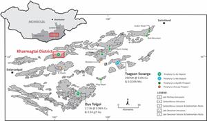
Location of the Kharmagtai Project in the South Gobi porphyry copper belt.
FIGURE 2
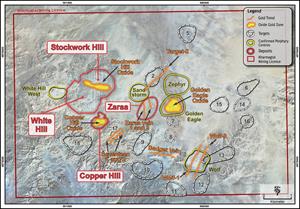
The Kharmagtai Mining Licence showing location of the Kharmagtai Deposits (Stockwork Hill, White Hill, Copper Hill) and areas being investigated for oxide gold at Kharmagtai.
FIGURE 3
Plan showing drill holes and previous drilling with section line one.
FIGURE 4
Plan showing drill holes and previous drilling with section line two.
FIGURE 5
Core photos of KHDDH532, shallow zone of oxide gold enrichment.
Legal Disclaimer:
EIN Presswire provides this news content "as is" without warranty of any kind. We do not accept any responsibility or liability
for the accuracy, content, images, videos, licenses, completeness, legality, or reliability of the information contained in this
article. If you have any complaints or copyright issues related to this article, kindly contact the author above.