TORONTO, Feb. 19, 2019 (GLOBE NEWSWIRE) -- Xanadu Mines Ltd (ASX: XAM, TSX: XAM) (“Xanadu” or “the Company”) is pleased to report that diamond drill hole KHDDH488, which is currently being drilled at the Company’s Kharmagtai porphyry copper and gold deposit in the south Gobi region of Mongolia (Figures 1 and 2) has intersected a significant zone of visible bornite-chalcopyrite copper mineralisation. The current drilling is targeting high-grade mineralisation associated with a causative copper and gold porphyry at depth, which is yet to be drilled.
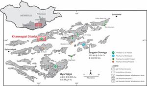
Location of the Kharmagtai Project in the South Gobi porphyry copper belt.
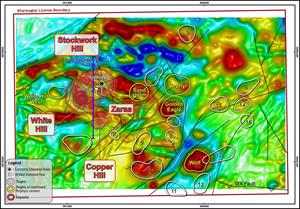
The Kharmagtai Mining Licence showing ground magnetic data and location of the Kharmagtai Deposit (Stockwork Hill, White Hill, Copper Hill), porphyry centres, targets and location of drill holes KHDDH488.
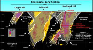
Long section showing KHDDH488 and KHDDH419. The block model represented in figure 3 was released as the mineral resource upgrade to Kharmagtai in press release dated 31 October, 2018. The conceptual pits designs within figure three are based on whittle optimisations generated during the mineral resource upgrade to Kharmagtai dated 31 October, 2018.
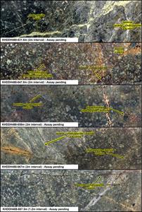
Mineralised slab images from KHDDH488. Halved HQ core, the height of each image is 6.35cm.
Estimation and modelling techniques
Bulk density
HIGHLIGHTS
Current drill hole (KHDDH488) has intersected porphyry style veining and tourmaline breccia with visible sulphide chalcopyrite mineralisation from 178m to current depth of 891m, with drilling continuing;
Within this larger interval is a 100m-wide zone of visible bornite-rich mineralisation occurring from a depth of 580m. Bornite visual estimates within this zone range from 0.1% to 1% bornite
Drilling is revealing a transition to higher temperature sulphide mineral assemblages such as bornite in the intrusive root to the deposit;
Assays are pending.
Xanadu’s Managing Director & Chief Executive Officer, Dr Andrew Stewart, said“The current focus on drilling for extensions to the high-grade resource at Kharmagtai is proceeding at pace and the mineralisation we are encountering supports this approach. The bornite‐rich cores of the Stockwork Hill and Copper Hill deposits provide encouragement that the Kharmagtai deposit has the capacity to produce high-grade ore zones characterised by bornite-gold mineralisation.
Hole KHDDH488 has successfully demonstrated the existence of high-grade mineralisation along strike and at depth outside the current resource. This represents an exciting new development for the project following the release of an interim open-cut resource last year and we are particularly excited with the new results from this hole which are expanding a new zone of bornite porphyry mineralisation. Bornite mineralisation typically carries significantly higher gold grades than chalcopyrite only zones.
Based upon detailed modelling, this new zone of mineralisation remains open in all directions. We have not yet found the core or the causative intrusion to mineralisation. The new high-grade extensions we have identified potentially provide the opportunity to assess Stockwork Hill as a larger open pit and as an underground resource that has the potential to deliver significant additional value to the Project.
We see these results as another step towards our goal of becoming a globally significant copper-gold company.”
STOCKWORK HILL DRILLING PROGRAM
The current drilling is targeting high-grade mineralisation associated with a causative copper and gold porphyry at depth which remains to be delineated. Drilling is targeting mineralisation below chalcopyrite‐gold mineralisation to test for a higher grade bornite core in the root zones of the causative porphyry intrusion. High grade mineralisation may be manifested as bornite‐gold‐cemented breccia or as bornite‐gold stockwork mineralisation in the causative intrusive intrusion.
Current diamond drill hole KHDDH488 is located approximately 100m east of KHDDH419 which intersected (see Xanadu’s ASX announcement – 26 September 2017; Figure 2):
− 294m @ 0.47% Cu & 0.85g/t Au (1.01% eCu or 1.59g/t eAu) from 466m, including 86m @ 0.78% Cu and 1.91g/t Au (2.0% eCu or 3.14g/t eAu) from 558m
Drill hole KHDDH488 is at a current depth of 891m, intersecting a quartz-diorite intrusion containing porphyry-style veins and tourmaline breccia with visible chalcopyrite and trace molybdenite and bornite mineralisation from 178m depth to the current depth of 891m (Figure 3 and 4).
Between the depths of 178 and 422m mineralisation occurs as porphyry vein infill, disseminations and infill to tourmaline breccias. Copper mineral species are dominated by chalcopyrite which ranges between 0.5% chalcopyrite and 1.5% chalcopyrite as a percentage of the whole rock.
Between the depths of 422m and 512m chalcopyrite mineralisation drops to between 0.1% to 0.5% chalcopyrite as disseminations and porphyry vein infill.
From the depth of 512m to the current hole depth 891m mineralisation occurs as both chalcopyrite and bornite sulphide, both occurring as disseminations and porphyry vein infill. Chalcopyrite abundances range between 0.5% to 4.5%. Within this interval is distinctive zone of bornite mineralisation between 580 to 680m ranging between 0.1% to 1% bornite in addition to the chalcopyrite.
These are visual estimates and do not represent assay results. Assay results are expected in the coming weeks.
The abundance of porphyry-type quartz veins, visual estimations of volume-percent chalcopyrite and the chalcopyrite-bornite ratio increases between 580m and 680m indicates that drilling is advancing towards higher temperature core of the Kharmagtai porphyry system (Figure 4).
It is likely that deeper drilling in the Kharmagtai deposit will reveal a transition to higher temperature sulphide mineral assemblages such as bornite in the intrusive root to the deposit.
Photos accompanying this announcement are available at
The information in this announcement that relates to exploration results is based on information compiled by Dr Andrew Stewart who is responsible for the exploration data, comments on exploration target sizes, QA/QC and geological interpretation and information. Dr Stewart, who is an employee of Xanadu and is a Member of the Australasian Institute of Geoscientists, has sufficient experience relevant to the style of mineralisation and type of deposit under consideration and to the activity he is undertaking to qualify as the “Competent Person” as defined in the 2012 Edition of the “Australasian Code for Reporting Exploration Results, Mineral Resources and Ore Reserves” and the National Instrument 43-101. Dr Stewart consents to the inclusion in the report of the matters based on this information in the form and context in which it appears.
COPPER EQUIVALENT CALCULATIONS
The copper equivalent (CuEq) calculation represents the total metal value for each metal, multiplied by the conversion factor, summed and expressed in equivalent copper percentage. Grades have not been adjusted for metallurgical or refining recoveries and the copper equivalent grades are of an exploration nature only and intended for summarising grade. The copper equivalent calculation is intended as an indicative value only. The following copper equivalent conversion factors and long-term price assumptions have been adopted: Copper Equivalent Formula (CuEq) = Cu% + (Au (ppm) x 0.6378). Based on a copper price of $2.60/lb and a gold price of $1,300/oz.
Table 1: Currently returned assay intercepts for Stockwork Hill
Hole ID
Prospect
From (m)
To (m)
Interval (m)
Au (g/t)
Cu (%)
CuEq (%)
AuEq (g/t)
KHDDH488
Stockwork Hill
Assays pending
Intercepts are weighted averages to ensure different sample lengths do not skew the results. There is insufficient information to understand true widths at this stage. Due to the size of the system and current ambiguity around orientation of the drill hole relative to minor diluting intrusives, a larger than normal internal dilution of 9m has been used to calculate a geologically relevant intercept. Cut-off grades and maximum dilution details are included in the tabulated intercepts for clarity.
Table 2: Drill hole collar location
Hole ID
Prospect
East
North
RL
Azimuth (°)
Inc (°)
Depth (m)
KHDDH488
Stockwork Hill
592741
4877800
1284
180
-73
901.0
For further information, please contact:
Andrew Stewart Managing Director & Chief Executive Officer T: +612 8280 7497 M: +976 9999 9211 Andrew.stewart@xanadumines.com www.xanadumines.com
APPENDIX 1: KHARMAGTAI TABLE 1 (JORC 2012) 1.1JORC TABLE 1 – SECTION 4 ESTIMATION AND REPORTING OF ORE RESERVES
Set out below is Section 1 and Section 2 of Table 1 under the JORC Code, 2012 Edition for the Kharmagtai project. Data provided by Xanadu. This Table 1 updates the JORC Table 1 disclosure dated 31 July 2018.
1.2JORC TABLE 1 - SECTION 1 - SAMPLING TECHNIQUES AND DATA
Criteria
JORC Code explanation
Commentary
Sampling techniques
Nature and quality of sampling (eg cut channels, random chips, or specific specialised industry standard measurement tools appropriate to the minerals under investigation, such as down hole gamma sondes, or handheld XRF instruments, etc). These examples should not be taken as limiting the broad meaning of sampling.
Include reference to measures taken to ensure sample representivity and the appropriate calibration of any measurement tools or systems used.
Aspects of the determination of mineralisation that are Material to the Public Report.
In cases where ‘industry standard’ work has been done this would be relatively simple (e.g. ‘reverse circulation drilling was used to obtain 1 m samples from which 3 kg was pulverised to produce a 30 g charge for fire assay’). In other cases more explanation may be required, such as where there is coarse gold that has inherent sampling problems. Unusual commodities or mineralisation types (e.g. submarine nodules) may warrant disclosure of detailed information.
The resource estimate is based on diamond drill core samples, RC chip samples and channel samples from surface trenches.
Representative ½ core samples were split from PQ, HQ & NQ diameter diamond drill core on site using rock saws, on a routine 2m sample interval that also honours lithological/intrusive contacts.
The orientation of the cut line is controlled using the core orientation line ensuring uniformity of core splitting wherever the core has been successfully oriented.
Sample intervals are defined and subsequently checked by geologists, and sample tags are attached (stapled) to the plastic core trays for every sample interval.
RC chip samples are ¼ splits from one meter intervals using a 75%:25% riffle splitter to obtain a 3kg sample
RC samples are uniform 2m samples formed from the combination of two ¼ split 1m samples.
Drilling techniques
Drill type (e.g. core, reverse circulation, open-hole hammer, rotary air blast, auger, Bangka, sonic, etc.) and details (e.g. core diameter, triple or standard tube, depth of diamond tails, face-sampling bit or other type, whether core is oriented and if so, by what method, etc).
The Mineral Resource estimation has been based upon diamond drilling of PQ, HQ and NQ diameters with both standard and triple tube core recovery configurations, RC drilling and surface trenching with channel sampling.
All drill core drilled by Xanadu has been oriented using the “Reflex Ace” tool.
Drill sample recovery
Method of recording and assessing core and chip sample recoveries and results assessed.
Measures taken to maximise sample recovery and ensure representative nature of the samples.
Whether a relationship exists between sample recovery and grade and whether sample bias may have occurred due to preferential loss/gain of fine/coarse material.
Diamond drill core recoveries were assessed using the standard industry (best) practice which involves: removing the core from core trays; reassembling multiple core runs in a v-rail; measuring core lengths with a tape measure, assessing recovery against core block depth measurements and recording any measured core loss for each core run.
Diamond core recoveries average 97% through mineralization.
Overall, core quality is good, with minimal core loss. Where there is localized faulting and or fracturing core recoveries decrease, however, this is a very small percentage of the mineralized intersections.
RC recoveries are measured using whole weight of each 1m intercept measured before splitting
Analysis of recovery results vs grade shows no significant trends that might indicate sampling bias introduced by variable recovery in fault/fracture zones.
Logging
Whether core and chip samples have been geologically and geotechnically logged to a level of detail to support appropriate Mineral Resource estimation, mining studies and metallurgical studies.
Whether logging is qualitative or quantitative in nature. Core (or costean, channel, etc) photography.
The total length and percentage of the relevant intersections logged.
All drill core is geologically logged by well-trained geologists using a modified “Anaconda-style” logging system methodology. The Anaconda method of logging and mapping is specifically designed for porphyry Cu-Au mineral systems and is entirely appropriate to support Mineral Resource Estimation, mining and metallurgical studies.
Logging of lithology, alteration and mineralogy is intrinsically qualitative in nature. However, the logging is subsequently supported by 4 Acid ICP-MS (48 element) geochemistry and SWIR spectral mineralogy (facilitating semi-quantitative/calculated mineralogical, lithological and alteration classification) which is integrated with the logging to improve cross section interpretation and 3D geological model development.
Drill core is also systematically logged for both geotechnical features and geological structures. Where drill core has been successfully oriented, the orientation of structures and geotechnical features are also routinely measured.
Both wet and dry core photos are taken after core has been logged and marked-up but before drill core has been cut.
Sub-sampling techniques and sample preparation
If core, whether cut or sawn and whether quarter, half or all core taken.
If non-core, whether riffled, tube sampled, rotary split, etc and whether sampled wet or dry.
For all sample types, the nature, quality and appropriateness of the sample preparation technique.
Quality control procedures adopted for all sub-sampling stages to maximise representivity of samples.
Measures taken to ensure that the sampling is representative of the in situ material collected, including for instance results for field duplicate/second-half sampling.
Whether sample sizes are appropriate to the grain size of the material being sampled.
All drill core samples are ½ core splits from either PQ, HQ or NQ diameter cores. A routine 2m sample interval is used, but this is varied locally to honour lithological/intrusive contacts. The minimum allowed sample length is 30cm.
Core is appropriately split (onsite) using diamond core saws with the cut line routinely located relative to the core orientation line (where present) to provide consistency of sample split selection.
The diamond saws are regularly flushed with water to minimize potential contamination.
A field duplicate ¼ core sample is collected every 30th sample to ensure the “representivity of the in situ material collected”. The performance of these field duplicates are routinely analysed as part of Xanadu’s sample QC process.
Routine sample preparation and analyses of DDH samples were carried out by ALS Mongolia LLC (ALS Mongolia), who operates an independent sample preparation and analytical laboratory in Ulaanbaatar.
All samples were prepared to meet standard quality control procedures as follows: Crushed to 75% passing 2mm, split to 1kg, pulverised to 85% passing 200 mesh (75 microns) and split to 150g sample pulp.
ALS Mongolia Geochemistry labs quality management system is certified to ISO 9001:2008.
The sample support (sub-sample mass and comminution) is appropriate for the grainsize and Cu-Au distribution of the porphyry Cu-Au mineralization and associated host rocks.
Quality of assay data and laboratory tests
The nature, quality and appropriateness of the assaying and laboratory procedures used and whether the technique is considered partial or total.
For geophysical tools, spectrometers, handheld XRF instruments, etc, the parameters used in determining the analysis including instrument make and model, reading times, calibrations factors applied and their derivation, etc.
Nature of quality control procedures adopted (eg standards, blanks, duplicates, external laboratory checks) and whether acceptable levels of accuracy (ie lack of bias) and precision have been established.
All samples were routinely assayed by ALS Mongolia for gold
Au is determined using a 25g fire assay fusion, cupelled to obtain a bead, and digested with Aqua Regia, followed by an atomic absorption spectroscopy (AAS) finish, with a lower detection (LDL) of 0.01 ppm.
All samples were also submitted to ALS Mongolia for the 48 element package ME-ICP61 using a four acid digest (considered to be an effective total digest for the elements relevant to the MRE). Where copper is over-range (>1% Cu), it is analysed by a second analytical technique (Cu-OG62), which has a higher upper detection limit (UDL) of 5% copper.
Quality assurance has been managed by insertion of appropriate Standards (1:30 samples – suitable Ore Research Pty Ltd certified standards), Blanks (1:30 samples), Duplicates (1:30 samples – ¼ core duplicate) by XAM.
Assay results outside the optimal range for methods were re-analysed by appropriate methods.
Ore Research Pty Ltd certified copper and gold standards have been implemented as a part of QC procedures, as well as coarse and pulp blanks, and certified matrix matched copper-gold standards.
QC monitoring is an active and ongoing processes on batch by batch basis by which unacceptable results are re-assayed as soon as practicable.
Prior to 2014: Cu, Ag, Pb, Zn, As and Mo were routinely determined using a three-acid-digestion of a 0.3g sub-sample followed by an AAS finish (AAS21R) at SGS Mongolia. Samples were digested with nitric, hydrochloric and perchloric acids to dryness before leaching with hydrochloric acid to dissolve soluble salts and made to 15ml volume with distilled water. The LDL for copper using this technique was 2ppm. Where copper was over-range (>1% Cu), it was analysed by a second analytical technique (AAS22S), which has a higher upper detection limit (UDL) of 5% copper. Gold analysis method was essentially unchanged.
Verification of sampling and assaying
The verification of significant intersections by either independent or alternative company personnel.
The use of twinned holes.
Documentation of primary data, data entry procedures, data verification, data storage (physical and electronic) protocols.
Discuss any adjustment to assay data.
All assay data QAQC is checked prior to loading into XAM’s Geobank data base.
The data is managed by XAM geologists.
The data base and geological interpretation is managed by XAM.
Check assays are submitted to an umpire lab (SGS Mongolia) for duplicate analysis.
No twinned drill holes exist.
There have been no adjustments to any of the assay data.
Location of data points
Accuracy and quality of surveys used to locate drill holes (collar and down-hole surveys), trenches, mine workings and other locations used in Mineral Resource estimation.
Specification of the grid system used.
Quality and adequacy of topographic control.
Diamond drill holes have been surveyed with a differential global positioning system (DGPS) to within 10cm accuracy.
The grid system used for the project is UTM WGS-84 Zone 48N
Historically, Eastman Kodak and Flexit electronic multi-shot downhole survey tools have been used at Kharmagtai to collect down hole azimuth and inclination information for the majority of the diamond drill holes. Single shots were typically taken every 30m to 50m during the drilling process, and a multi-shot survey with readings every 3-5m are conducted at the completion of the drill hole. As these tools rely on the earth’s magnetic field to measure azimuth, there is some localised interference/inaccuracy introduced by the presence of magnetite in some parts of the Kharmagtai mineral system. The extent of this interference cannot be quantified on a reading-by-reading basis.
More recently (since September 2017), a north-seeking gyro has been employed by the drilling crews on site (rented and operated by the drilling contractor), providing accurate downhole orientation measurements unaffected by magnetic effects. Xanadu have a permanent calibration station setup for the gyro tool, which is routinely calibrated every 2 weeks (calibration records are maintained and were sighted)
The project DTM is based on 1 m contours from satellite imagery with an accuracy of ±0.1 m.
Data spacing and distribution
Data spacing for reporting of Exploration Results.
Whether the data spacing and distribution is sufficient to establish the degree of geological and grade continuity appropriate for the Mineral Resource and Ore Reserve estimation procedure(s) and classifications applied.
Whether sample compositing has been applied.
Holes spacings range from <50m spacings within the core of mineralization to +500m spacings for exploration drilling. Hole spacings can be determined using the sections and drill plans provided.
Holes range from vertical to an inclination of -60 degrees depending on the attitude of the target and the drilling method.
The data spacing and distribution is sufficient to establish anomalism and targeting for porphyry Cu-Au, tourmaline breccia and epithermal target types.
Holes have been drilled to a maximum of 1,300m vertical depth.
The data spacing and distribution is sufficient to establish geological and grade continuity, and to support the Mineral Resource classification.
Orientation of data in relation to geological structure
Whether the orientation of sampling achieves unbiased sampling of possible structures and the extent to which this is known, considering the deposit type.
If the relationship between the drilling orientation and the orientation of key mineralised structures is considered to have introduced a sampling bias, this should be assessed and reported if material.
Drilling is conducted in a predominantly regular grid to allow unbiased interpretation and targeting.
Scissor drilling, as well as some vertical and oblique drilling, has been used in key mineralised zones to achieve unbiased sampling of interpreted structures and mineralised zones, and in particular to assist in constraining the geometry of the mineralised hydrothermal tourmaline-sulphide breccia domains.
Sample security
The measures taken to ensure sample security.
Samples are delivered from the drill rig to the core shed twice daily and are never left unattended at the rig.
Samples are dispatched from site in locked boxes transported on XAM company vehicles to ALS lab in Ulaanbaatar.
Sample shipment receipt is signed off at the Laboratory with additional email confirmation of receipt.
Samples are then stored at the lab and returned to a locked storage site.
Audits or reviews
The results of any audits or reviews of sampling techniques and data.
Internal audits of sampling techniques and data management are undertaken on a regular basis, to ensure industry best practice is employed at all times.
External reviews and audits have been conducted by the following groups:
2012: AMC Consultants Pty Ltd. was engaged to conduct an Independent Technical Report which reviewed drilling and sampling procedures. It was concluded that sampling and data record was to an appropriate standard.
2013: Mining Associates Ltd. was engaged to conduct an Independent Technical Report to review drilling, sampling techniques and QAQC. Methods were found to conform to international best practice.
2018: CSA Global reviewed the entire drilling, logging, sampling, sample shipping and laboratory processes during the competent persons site visit for the 2018 MRe, and found the systems and adherence to protocols to be to an appropriate standard.
Type, reference name/number, location and ownership including agreements or material issues with third parties such as joint ventures, partnerships, overriding royalties, native title interests, historical sites, wilderness or national park and environmental settings.
The security of the tenure held at the time of reporting along with any known impediments to obtaining a licence to operate in the area.
The Project comprises 1 Mining Licence (MV-17387A).
The Kharmagtai mining license MV-17387A is 100% owned by Oyut Ulaan LLC. THR Oyu Tolgoi Ltd (a wholly owned subsidiary of Turquoise Hill Resources Ltd) (“THR”) owns 90% of Oyut Ulaan LLC. The remaining 10% is owned by Quincunx Ltd (“Quincunx”).
The Mongolian Minerals Law (2006) and Mongolian Land Law (2002) govern exploration, mining and land use rights for the project.
Exploration done by other parties
Acknowledgment and appraisal of exploration by other parties.
Detailed exploration was conducted by Quincunx Ltd, Ivanhoe Mines Ltd and Turquoise Hill Resources Ltd including extensive surface mapping, trenching, diamond drilling, surface geochemistry and geophysics.
Geology
Deposit type, geological setting and style of mineralisation.
The mineralisation is characterised as porphyry copper-gold type.
Porphyry copper-gold deposits are formed from magmatic hydrothermal fluids typically associated with felsic intrusive stocks that have deposited metals as sulphides both within the intrusive and the intruded host rocks. Quartz stockwork veining is typically associated with sulphides occurring both within the quartz veinlets and disseminated thought out the wall rock. Porphyry deposits are typically large tonnage deposits ranging from low to high grade and are generally mined by large scale open pit or underground bulk mining methods. The prospects at Kharmagtai are atypical in that they are associated with intermediate intrusions of diorite to quartz diorite composition; however the deposits are significant in terms of gold:copper ratio, and similar to other gold-rich porphyry deposits.
Drill hole Information
A summary of all information material to the understanding of the exploration results including a tabulation of the following information for all Material drill holes:
easting and northing of the drill hole collar
elevation or RL (Reduced Level – elevation above sea level in metres) of the drill hole collar
dip and azimuth of the hole
down hole length and interception depth
hole length.
If the exclusion of this information is justified on the basis that the information is not Material and this exclusion does not detract from the understanding of the report, the Competent Person should clearly explain why this is the case.
Diamond holes, RC holes and trenches are the principal source of geological and grade data for the Project.
Timing
RC Holes
Metre
DDH Holes
Metre
RC & DDH
Metre
Trench
Metre
Drilling <2015
155
24553
252
88511
0
0
106
39774
Drilling >2015
68
13107
116
57876
22
5323
17
5618
Total
223
37660
368
146387
22
5323
123
45392
See figures in main report.
Data aggregation methods
In reporting Exploration Results, weighting averaging techniques, maximum and/or minimum grade truncations (eg cutting of high grades) and cut-off grades are usually Material and should be stated.
Where aggregate intercepts incorporate short lengths of high grade results and longer lengths of low grade results, the procedure used for such aggregation should be stated and some typical examples of such aggregations should be shown in detail.
The assumptions used for any reporting of metal equivalent values should be clearly stated.
Weighted averages have not been used in this work
Some compositing has been used in this resource but with statistically relevant techniques that do not include internal dilution
The following metal equivalent calculations were used:
CuEq = Cu% + (Au g/t x 0.51139)
Formula is based on a $3.1/lb copper price and a $1,320/oz gold price. A relative gold to copper recovery factor of 82.35% was used (85% copper recovery and 70% gold recovery), gold to copper conversion factor of 0.62097 was applied. All prices are in USD.
Relationship between mineralisation widths and intercept lengths
These relationships are particularly important in the reporting of Exploration Results.
If the geometry of the mineralisation with respect to the drill hole angle is known, its nature should be reported.
If it is not known and only the down hole lengths are reported, there should be a clear statement to this effect (e.g. ‘down hole length, true width not known’).
Mineralised structures are variable in orientation, and therefore drill orientations have been adjusted from place to place in order to allow intersection angles as close as possible to true widths.
Exploration results have been reported as an interval with 'from' and 'to' stated in tables of significant economic intercepts. Tables clearly indicate that true widths will generally be narrower than those reported.
Diagrams
Appropriate maps and sections (with scales) and tabulations of intercepts should be included for any significant discovery being reported These should include, but not be limited to a plan view of drill hole collar locations and appropriate sectional views.
See figures in main report.
Balanced reporting
Where comprehensive reporting of all Exploration Results is not practicable, representative reporting of both low and high grades and/or widths should be practiced to avoid misleading reporting of Exploration Results.
Resources have been reported at a range of cut-off grades, above a minimum suitable for open pit mining, and above a minimum suitable for underground mining.
Other substantive exploration data
Other exploration data, if meaningful and material, should be reported including (but not limited to): geological observations; geophysical survey results; geochemical survey results; bulk samples – size and method of treatment; metallurgical test results; bulk density, groundwater, geotechnical and rock characteristics; potential deleterious or contaminating substances.
Extensive work in this area has been done and is reported separately. See the company website for significant announcements and milestones. Work that has been done includes; relogging of core, structural studies, alteration studies, geotechnical studies and preliminary metallurgical test works. The project has been subject to various geophysical studies including aeromagnetic, radiometric surveys and electromagnetic surveys over discrete targets.
Further work
The nature and scale of planned further work (e.g. tests for lateral extensions or depth extensions or large-scale step-out drilling).
Diagrams clearly highlighting the areas of possible extensions, including the main geological interpretations and future drilling areas, provided this information is not commercially sensitive.
The mineralisation is open at depth and along strike.
Current estimates are restricted to those expected to be reasonable for open pit mining. Limited drilling below this depth (- 300m rl) shows widths and grades potentially suitable for underground extraction.
Exploration is on-going.
1.4JORC TABLE 1 – SECTION 3 ESTIMATION AND REPORTING OF MINERAL RESOURCES
Criteria
JORC Code explanation
Commentary
Database integrity
Measures taken to ensure that data has not been corrupted by, for example, transcription or keying errors, between its initial collection and its use for Mineral Resource estimation purposes.
Data validation procedures used.
The database is managed using Micromine Geobank software. Data is logged directly into an Excel spread sheet logging system with drop down field lists. Validation checks are written into the importing program ensures all data is of high quality. Digital assay data is obtained from the Laboratory, QA/QC checked and imported. Geobank exported to CSV TEXT and imported directly to the Micromine software used for the MRE.
The combined database was provided for the MRE.
Validation of the data import include checks for the following:
Duplicate drill hole or trench names,
One or more drill hole collar or trench coordinates missing in the collar file,
FROM or TO missing or absent in the assay file,
FROM > TO in the assay file,
Sample intervals overlap in the assay file,
First sample is not equal to 0 m in the assay file,
First depth is not equal to 0 m in the survey file,
Several downhole survey records exist for the same depth,
Azimuth is not between 0 and 360° in the survey file,
Dip is not between 0 and 90° in the survey file,
Azimuth or dip is missing in survey file,
Total depth of the holes is less than the depth of the last sample,
Total length of trenches is less than the total length of all samples.
Negative sample grades.
No logical errors were identified in the analytical data.
Site visits
Comment on any site visits undertaken by the Competent Person and the outcome of those visits.
If no site visits have been undertaken indicate why this is the case.
Warren Potma, an employee of CSA Global, visited the Kharmagtai project, located in Mongolia, over 4 days from 18th to 22nd September 2018.
The site visit was required for the purposes of inspection, ground truthing, review of activities, and collection of information and data.
Geological interpretation
Confidence in (or conversely, the uncertainty of ) the geological interpretation of the mineral deposit.
Nature of the data used and of any assumptions made.
The effect, if any, of alternative interpretations on Mineral Resource estimation.
The use of geology in guiding and controlling Mineral Resource estimation.
The factors affecting continuity both of grade and geology.
Geological data has been collected in a consistent manner that has allowed the development of geological models to support the Mineral Resource estimate. Copper and gold mineralisation is controlled by porphyry phases, oxidation zone, level of veining, breccia, country rocks and barren dykes.
Full geological models of all major geological formations were developed for each deposit, and the block models were domained accordingly.
Domaining of the deposit mineralisation was based on the current understanding of the deposits’ geology. All major geological formations were wireframed by Xanadu geologists using Leapfrog software, including porphyry phases, country rocks, barren dyke, base of oxidation surface and breccia bodies. All geological formations were domained by the level of development of stockwork - <0.5% veining, 0.5-1.5% veining and >1.5% veining. All provided wireframe models were imported into Micromine software and validated by CSA Global.
Geological interpretation and wireframing were based on sampling results of drill holes and trenches, which were logged at 2 m intervals (average).
No alternative interpretations were adopted.
Lithological logging was mainly used to interpret and to wireframe the geological formations. Geological logging of veining was used to wireframe the stockwork and breccia domains.
Dimensions
The extent and variability of the Mineral Resource expressed as length (along strike or otherwise), plan width, and depth below surface to the upper and lower limits of the Mineral Resource.
Altan Tolgoi: The strike length of the mineralised zone is about 1,200 m. Width is up to 800 m, no plunging, traced down dip to 1,030 m. Mineralisation is outcropped at the surface.
Tsagaan Sudal: The strike length of the mineralised zone is about 1,200 m. Width is up to 730 m, no plunging, traced down dip to 1,080 m. Mineralisation is outcropped at the surface.
Zesen Uul: The strike length of the mineralised zone is about 630 m. Width is up to 150 m with apparent plunging to SW at about 40 degrees. traced down dip to 420 m dipping 70 degrees to SE. Mineralisation is outcropped at the surface.
Estimation and modelling techniques
The nature and appropriateness of the estimation technique(s) applied and key assumptions, including treatment of extreme grade values, domaining, interpolation parameters and maximum distance of extrapolation from data points. If a computer assisted estimation method was chosen include a description of computer software and parameters used.
The availability of check estimates, previous estimates and/or mine production records and whether the Mineral Resource estimate takes appropriate account of such data.
The assumptions made regarding recovery of by-products.
Estimation of deleterious elements or other non-grade variables of economic significance (e.g. sulphur for acid mine drainage characterisation).
In the case of block model interpolation, the block size in relation to the average sample spacing and the search employed.
Any assumptions behind modelling of selective mining units.
Any assumptions about correlation between variables.
Description of how the geological interpretation was used to control the resource estimates.
Discussion of basis for using or not using grade cutting or capping.
The process of validation, the checking process used, the comparison of model data to drill hole data, and use of reconciliation data if available.
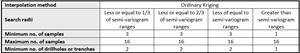
The MRE is based on surface drilling and trenching results using Ordinary Kriging (OK) to inform 20 m x 20 m x 20 m blocks. The block model was constrained by wireframes modelled for the geological formations of the deposits and coded and domained by the level of oxidation and level of veining. The OK interpolation was carried out separately for each geological domain of each deposit. Hard boundaries were used between the interpreted geological domains. The drill hole and trench data were composited to a target length of 2 m based on the length analysis of raw intercepts. Top-cuts were estimated separately for gold and coper grades for each modelled domain and applied to sampled intervals before length compositing. Interpolation parameters were as follows:
Previous JORC-compliant Mineral Resources were estimated by Mining Associates, and the estimate was available for review.
No current mining is occurring at the Kharmagtai project.
No by-products are assumed at this stage. Estimated molybdenum and silver grades appear to be sub-economic to extract at this stage of the project evaluation.
Sulphur grades were interpolated into the models to establish their potential affect to metallurgical processing.
The optimal parent cell size was selected in the course of block modelling. The linear parent cell dimensions along X- and Y-axes were 20 m x 20 m. The vertical parent cell dimension was 20 m. Block grades were interpolated using parent cell estimation. Nominal drill spacing was about 40 m x 40 m at the central parts of the deposits.
It was assumed that a 20 m x 20 m x 20 m parent cell approximately reflects SMU for large scale open pit mining.
No assumptions about correlation between variables were made.
Geological interpretation was based on the results of detailed geological logging, which resulted in the development of wireframe models for all major geological formations for each deposit, which control copper and gold mineralisation (country rocks, porphyry phases, barren dyke. Logging of the level of veining and level of oxidation was used to develop wireframe models for the stockwork development (<0.5% veining, 0.5-1.5% veining and >1.5% veining) and also for breccia pipe and surface for the base of oxidation surface. The wireframe models for stockwork, breccia and oxidation were used to sub-domain the main geological formations of each deposit. All wireframe models were developed by Xanadu geologists using Leapfrog software.
Top-cutting was applied separately for each geological domain and sub-domain based on the results of the classical statistical analysis.
Grade estimation was validated using visual inspection of interpolated block grades vs. sample data, alternative interpolation methods and swath plots.
Moisture
Whether the tonnages are estimated on a dry basis or with natural moisture, and the method of determination of the moisture content.
Moisture was not considered in the density assignment and all tonnage estimates are based on dry tonnes.
Cut-off parameters
The basis of the adopted cut-off grade(s) or quality parameters applied.
A cut-off grade of 0.3% CuEq was used to report the Mineral Resources for open pit mining within the limits of ultimate undiscounted pit shell, and a cut-off of 0.5% CuEq was used to report the Mineral Resources for underground mining below the ultimate undiscounted pit shell.
Mining factors or assumptions
Assumptions made regarding possible mining methods, minimum mining dimensions and internal (or, if applicable, external) mining dilution. It is always necessary as part of the process of determining reasonable prospects for eventual economic extraction to consider potential mining methods, but the assumptions made regarding mining methods and parameters when estimating Mineral Resources may not always be rigorous. Where this is the case, this should be reported with an explanation of the basis of the mining assumptions made.
No mining factors have been applied to the in-situ grade estimates for mining dilution or loss as a result of the grade control or mining process. The deposit is amenable to large scale bulk mining. The Mineral Resource is reported above and outside of an optimised ultimate pit shell (Lerch Grossman algorithm), mineralisation below the pit shell is reported at a higher cut-off to reflect the increased costs associated with block cave underground mining.
Metallurgical factors or assumptions
The basis for assumptions or predictions regarding metallurgical amenability. It is always necessary as part of the process of determining reasonable prospects for eventual economic extraction to consider potential metallurgical methods, but the assumptions regarding metallurgical treatment processes and parameters made when reporting Mineral Resources may not always be rigorous. Where this is the case, this should be reported with an explanation of the basis of the metallurgical assumptions made.
No metallurgical factors have been applied to the in-situ grade estimates. Metallurgical recoveries were used when copper equivalent grades were calculated in the model. The applied recoveries were 85% for copper and 70% for gold. Relative gold to copper recovery was 82%.
Environmental factors or assumptions
Assumptions made regarding possible waste and process residue disposal options. It is always necessary as part of the process of determining reasonable prospects for eventual economic extraction to consider the potential environmental impacts of the mining and processing operation. While at this stage the determination of potential environmental impacts, particularly for a greenfields project, may not always be well advanced, the status of early consideration of these potential environmental impacts should be reported. Where these aspects have not been considered this should be reported with an explanation of the environmental assumptions made.
An environmental baseline study was completed in 2003 by Eco Trade Co. Ltd. of Mongolia in cooperation with Sustainability Pty Ltd of Australia. The baseline study report was produced to meet the requirements for screening under the Mongolian Environmental Impact Assessment (EIA) Procedures administered by the Mongolian Ministry for Nature and Environment (MNE).
Bulk density
Whether assumed or determined. If assumed, the basis for the assumptions. If determined, the method used, whether wet or dry, the frequency of the measurements, the nature, size and representativeness of the samples.
The bulk density for bulk material must have been measured by methods that adequately account for void spaces (vugs, porosity, etc.), moisture and differences between rock and alteration zones within the deposit.
Discuss assumptions for bulk density estimates used in the evaluation process of the different materials.
A total of 4428 measurements for bulk density are recorded in the database, all of which were determined by the water immersion method.
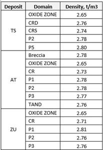
The average density of all samples is approximately 2.75 t/m3. In detail there are some differences in density between different rock types. Therefore, since the model includes all major geological domains, density values were applied separately for each domain:
Average bulk density values were applied for each geological domain, though there could be variations in density values due to presence of sulphides or level of alteration.
Classification
The basis for the classification of the Mineral Resources into varying confidence categories.
Whether appropriate account has been taken of all relevant factors (i.e. relative confidence in tonnage/grade estimations, reliability of input data, confidence in continuity of geology and metal values, quality, quantity and distribution of the data).
Whether the result appropriately reflects the Competent Person’s view of the deposit.
The Mineral Resource has been classified based on the guidelines specified in the JORC Code. The classification level is based upon an assessment of geological understanding of the deposit, geological and mineralization continuity, drill hole spacing, QC results, search and interpolation parameters and an analysis of available density information.
The following approach was adopted:
Measured Resources: Not reported.
Indicated Resources: It was decided that Indicated Mineral Resources be assigned to blocks which were explored with the drill density not exceeding approximately 65 m x 65 m with at least two mineralization intersections on exploration lines. Geological structures are relatively well understood and interpreted.
Inferred Resources: Inferred Mineral Resources are model blocks lying outside the Indicated wireframes, which still display reasonable strike continuity and down dip extension, based on the current drill hole and trench intersections.
Data quality, grade continuity, structural continuity and drill spacing were assessed by CSA Global to form an opinion regarding resource confidence.
The classification reflects the Competent Person’s view of the deposit.
Audits or reviews
The results of any audits or reviews of Mineral Resource estimates.
The Mineral Resource block model was peer reviewed internally by a Principal Resource Geologist employed by CSA Global and the conclusion was made that the procedures used to estimate and classify the Mineral Resource are appropriate.
Discussion of relative accuracy/ confidence
Where appropriate a statement of the relative accuracy and confidence level in the Mineral Resource estimate using an approach or procedure deemed appropriate by the Competent Person. For example, the application of statistical or geostatistical procedures to quantify the relative accuracy of the resource within stated confidence limits, or, if such an approach is not deemed appropriate, a qualitative discussion of the factors that could affect the relative accuracy and confidence of the estimate.
The statement should specify whether it relates to global or local estimates, and, if local, state the relevant tonnages, which should be relevant to technical and economic evaluation. Documentation should include assumptions made and the procedures used.
These statements of relative accuracy and confidence of the estimate should be compared with production data, where available.
Industry standard modelling techniques were used, including but not limited to:
Classical statistical analysis,
Interpretation and wireframing of main geological formations,
Top-cutting and interval compositing,
Domaining of the model using level of logging veining, breccia and zone of oxidation,
Geostatistical analysis,
Block modelling and grade interpolation techniques,
Model classification, validation and reporting, The relative accuracy of the estimate is reflected in the classification of the deposit.
The estimate is related to the global estimate of the deposit suitable for subsequent PFS or further exploration at the deposit.
No historical production data is available for comparison with the MRE.
The Mineral Resource accuracy is communicated through the classification assigned to various parts of the deposit.
1.5JORC TABLE 1 – SECTION 4 ESTIMATION AND REPORTING OF ORE RESERVES
Ore Reserves are not reported so this is not applicable to this report.
Legal Disclaimer:
EIN Presswire provides this news content "as is" without warranty of any kind. We do not accept any responsibility or liability
for the accuracy, content, images, videos, licenses, completeness, legality, or reliability of the information contained in this
article. If you have any complaints or copyright issues related to this article, kindly contact the author above.