Louisiana Student Wins National GIS Competition Mentored by Baton Rouge Based Non-Profit GGI
GGI provides students with opportunities to learn about GIS Technology and solve real-world problems.

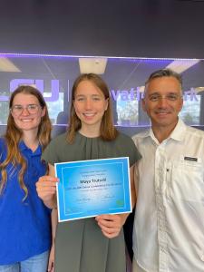
Maya Trutschi, winner of first place in the middle school division of the ArcGIS Online Competition for US High Schools and Middle Schools, accepts her certificate with GGI representative Sara Pellegrin and her father.

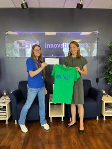
Maya Trutschi, with GGI representative Sara Pellegrin, accepts a cash prize and GIS T-shirt for her winning project, "The Unexpected Modernism of the South". Her project explored Shreveport's architectural history and future.
Over 500 high school and middle school students competed in the national ArcGIS Online Competition, utilizing GIS Technology to Map Home State Issues
Esri's ArcGIS Online Competition for US High and Middle schools asked students to create and submit original ArcGIS map projects inspired by their home states. The projects ranged from studying architecture's effect on modernism to lead exposure. The competition allows students to use Esri's GIS software, which is offered for free for instructional use in every K–12 school. Students—working alone or in teams of two—complete a custom project about a topic in their state where they gather, create, analyze, interpret, and present data via an ArcGIS StoryMaps story. Students choose and construct their own stories and assemble essential background information while building skills for college and serving their community.
Out of over 500 entries, two winners were selected and three honorable mentions. Hannah Osborne (TN) won the high school competition with "Standing Alone," and Louisiana 8th grade student Maya Trutschl's (LA) project, "The Unexpected Modernism of the South," won the middle school competition. States that participated were awarded $100 to the five best high schools (grades 9-12) and the five best middle schools (grades 4-8) in their respective states.
Trutshchi's project addressed the question, "How can we utilize geospatial data to show that Shreveport, Louisiana, should be recognized as the Design Capital of the Arkansas-Louisiana-Texas region with its complex mid-twentieth-century American architecture, hidden in plain sight in the 21st century?". To learn more, visit the 2022 competition, which includes links to projects by all awardees.
Global Geospatial Institute, a Baton Rouge-based nonprofit, continues to partner with national organizations and schools to expand awareness of the many uses of Geographical Information System (GIS) technology. Through its partnership with Esri, a global leader in location intelligence, GGI can help students explore a range of other subjects using ArcGIS Storymap technology.
"When you connect young people to an activity that is relevant in nearly any career path—transportation, government, business, science, conservation, environment, education, agriculture, emergency planning, forestry, firefighting, community planning or health care and the application is fun, everybody wins!" Harvey said.
Harvey, an alumnae member of the T3G Institute (Teachers Teaching Teachers GIS), invited the high school and middle school winner of the ArcGIS Online Competition for Schools and their respective state GIS representatives to showcase and talk about the student's winning story map projects on June 16 at the offices of Global Geospatial Institute (GGI). GGI leads the state team, which sponsors the annual competition. T3G is a career-long professional development for educators by educators to help teachers teach effectively with GIS. "I am a graduate of the T3G Institute, this serves as part of my training and education to teach GIS," Harvey said, "At T3G, the focus is on teaching and learning. We aim to help other educators grasp why and how to teach with GIS with an emphasis on engaging students in the learning process".
History and Future of the ArcGIS Competition
The ArcGIS Online Competition for US High Schools and Middle Schools began after Minnesota ran a successful state-based competition in 2016, encouraging Esri to use the model nationally. "Our investment in programs that help equip youth with GIS tools and techniques is one way for us to foster a sense of geographic curiosity and to encourage the next generation of scientific problem solvers." said Jack Dangermond, Esri founder and president
Using GIS Technologies to Improve our Local Communities
Fran Harvey founded and is the CEO of Global Geospatial Institute (GGI), a nonprofit specializing in GIS technology capable of building digital surveys to accumulate valuable data. GGI, a nonprofit specializing in GIS technology, aims to teach students K-12 how to build digital surveys to accumulate valuable data. Harvey believes this will help these students gain better jobs and become global citizens.
As a volunteer and sponsor of the LA 4-H Tech Club, composed of local Baton Rouge high school and middle school students, Harvey built a digital survey for Clean Pelican volunteers and students to input data about the bus benches. The project was presented to the Baton Rouge Metro Council in May 2022. Emboldened by GGI's support, students from Liberty Magnet and Episcopal High School in East Baton Rouge recently presented concerns about broken and dangerously placed bus benches and the lack of trash receptacles at bus stops to the East Baton Rouge Metro Council. Joseph Harden, a junior attending Liberty Magnet High School, and Caroline Waters, a sophomore attending Episcopal High School, presented results of a GIS survey that he and fellow LA 4-H Tech Club members used to assess the condition of bus stops in one capital city district.
About GGI
GGI performs educational outreach as the only accredited entity approved by Louisiana Workforce Investment Council to educate Louisiana students for an Industry-Based Certification program in Geographic Information Systems (GIS). GGI's education initiatives include partnerships with LSU's Agricultural Center 4H, Louisiana Geographic Educators Alliance, the city of Baton Rouge, and the Mighty Maps Institute. The organization's goal is to place GIS and Remote Sensing (RS) technology in the hands of as many students as possible.
About Esri
Esri, the global market leader in geographic information system (GIS) software, location intelligence, and mapping, helps customers unlock the full potential of data to improve operational and business results. Founded in 1969 in Redlands, California, USA, Esri software is deployed in more than 350,000 organizations globally and over 200,000 institutions in the Americas, Asia and the Pacific, Europe, Africa, and the Middle East, including Fortune 500 companies, government agencies, nonprofits, and universities. Esri has regional offices, international distributors, and partners providing local support in over 100 countries on six continents. With its pioneering commitment to geospatial information technology, Esri engineers the most innovative solutions for digital transformation, the Internet of Things (IoT), and advanced analytics. For more information, visit esri.com.
Fran Harvey
Global Geospatial Institute
+1 225-939-3907
email us here
Visit us on social media:
Facebook
LinkedIn
Other


