
Ohio’s New U.S. Congressional Districts Challenged as Unconstitutional
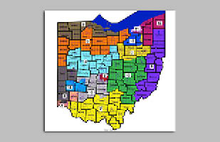
Legislative leaders and voter groups clash over the General Assembly’s new map for the state’s 15 U.S. House districts.
Legislative leaders and voter groups clash over the General Assembly’s new map for the state’s 15 U.S. House districts.
Another set of cases about Ohio’s reforms to creating districts for the public’s representatives has reached the Ohio Supreme Court. Two cases to be argued tomorrow turn on the 2018 constitutional amendments directing how to draw Ohio’s districts for the U.S. House of Representatives.
The Ohio Constitution assigns the work of drawing the U.S. House districts primarily to the General Assembly. The process relies on U.S. census data collected every 10 years – which this year reached the state in August, much later than the typical March delivery.
In November, the state legislature passed a bill enacting a map of Ohio’s 15 U.S. House districts. The legislation passed by a simple majority and without bipartisan support. Advocacy groups and individuals filed lawsuits in the Supreme Court, asserting that the map violates the mandates voters approved in the 2018 constitutional amendments.
The Court has combined the cases for tomorrow’s oral argument – allotting 30 minutes for each side. The governor, state auditor, and Democratic members of the Ohio Redistricting Commission were named initially in the cases, but the Court has dismissed them. The majority leaders of the Ohio Senate and Ohio House of Representatives remain parties in the cases, in their roles as Senate president and House speaker. The secretary of state also is named in the suits.
The trio of cases heard by the Ohio Supreme Court earlier this month addressed separate constitutional changes that reformed the map-drawing of the Ohio Senate and House districts. Those maps were constructed by the redistricting commission. The Court has not yet ruled in those disputes.
Ohioans Vote to Change Method for Drawing U.S. House Districts In May 2018, 75% of Ohio voters approved the reforms to the process for shaping the state’s districts in the U.S. House. The constitutional amendments were designed to eliminate the gerrymandering of districts through “a fair, bipartisan, and transparent process” that would “make politicians more accountable to the voters,” the ballot language stated.
According to Article XIX of the Ohio Constitution, the General Assembly “shall pass” a congressional district plan in the Ohio House and the Ohio Senate – with three-fifths of members voting yes, including a certain level of bipartisan support – by the last day of September. If the plan isn’t passed by that date and filed with the secretary of state, then the seven-member redistricting commission “shall adopt” a map with bipartisan support by the end of October. If the commission fails to adopt a plan by that time, the duty returns to the state legislature, which must pass a bill enacting a U.S. House district map by the last day of November.
This year, the General Assembly didn’t pass a plan by Sept. 30 and the redistricting commission didn’t propose or adopt a plan by Oct. 31, so the work of congressional redistricting returned to the legislature. The Ohio Senate introduced a bill with a district plan on Nov. 15 and it passed the next day, followed by the Ohio House’s passage of the legislation on Nov. 18. The bill was signed by the governor and became law.
The legislature enacted the plan without the bipartisan support constitutionally required to keep the map in place for 10 years. When a plan is approved in this way, the map remains effective for four years, and the constitution states that “all of the following shall apply:”
“(a) The general assembly shall not pass a plan that unduly favors or disfavors a political party or its incumbents. (b) The general assembly shall not unduly split governmental units, giving preference to keeping whole, in the order named, counties, then townships and municipal corporations. (c) Division (B)(2) of Section 2 of this article shall not apply to the plan. [That provision states, “Every congressional district must be compact.”] The general assembly shall attempt to draw districts that are compact. (d) The general assembly shall include in the plan an explanation of the plan’s compliance with divisions (C)(3)(a) to (c) of this section. (e) If the plan becomes law, the plan shall remain effective until two general elections for the United States house of representatives have occurred under the plan, except as provided in Section 3 of this article.”
New Map ‘Unduly Favors’ One Party, Groups Argue In the first case, Adams et al. v. Gov. DeWine et al., Regina Adams of Maple Heights and 11 other Ohio voters contend that the approved four-year map for the U.S. House districts “unduly favors” the Republican Party and “unduly disfavors” the Democratic Party – in violation of the state constitution. They maintain that the 2021 plan creates 11 safe Republican districts, two safe Democratic districts, and only two competitive districts.
The map unduly favors Republicans because its partisan favoritism is excessive, they argue, calculating that 12 of Ohio’s 15 seats – or 80% – will likely go to Republicans because of the way the districts were drawn. Based on an expert’s analysis, the voters maintain in their brief that the plan dilutes Democratic votes around cities, “often cracking communities of color and submerging them in overwhelmingly white, Republican districts” to achieve the desired result.
Those who filed the second case, League of Women Voters of Ohio et al. v. Ohio Redistricting Commission et al., agree. The League of Women Voters of Ohio (LWV), the A. Philip Randolph Institute of Ohio, and eight voters argue the 2021 map is more gerrymandered than the congressional map drawn in 2011 – the one that drove the reforms put in place by the 2018 constitutional amendments.
The legislative leaders could choose from several categories of past election data for drawing the maps, including varied combinations of statewide election results and federal election results from 2012 to 2020. The LWV objects to the leaders’ chosen data set – which LWV states included only selected federal elections (the presidential and U.S. Senate races between 2012 and 2020) and excluded U.S. House races. By using that limited set of data, the LWV alleges, the map made districts appear more competitive. That data understates Republican strength in all districts, allowing the legislative leaders to claim more districts are competitive – but when other statewide election results are considered, those districts are likely to be won by Republicans, the LWV asserts.
“[B]y any measure the Enacted Plan is materially more biased in favor of the Republican Party than the 2011 Plan,” the LWV brief states.
New Map Is Most Balanced and Fair in Years, Legislative Leaders Maintain Senate President Matt Huffman and House Speaker Robert Cupp, both Republicans, contend that the approved map contains six Republican-leaning districts, two Democratic-leaning districts, and seven competitive districts. They maintain they used the federal election data to support their map because it is the more appropriate metric for districts in federal elections.
They dispute any alleged undue favoritism, countering that the constitution offers no definitive standard for determining such favoritism and the standard to apply is open to interpretation. Citing the 2012 Ohio Supreme Court ruling in Wilson v. Kasich, the legislators argue the Court must defer to the General Assembly’s discretion and interpretation regarding whether a map “unduly favors or disfavors a political party.”
One interpretation of a fair map could be discerned from the 2020 general election results, they maintain. That year, 12 Republicans and four Democrats were elected to the U.S. House. But for the 2021 map, they drew safe seats for incumbents in eight districts – leaving seven within a partisan range that their experts describe as competitive, the legislators assert. They conclude in their brief that the resulting map is “the most balanced and politically fair congressional plan in recent Ohio history.”
They stress there is no proportionality standard in Article XIX as there is in Article XI, which sets the standards for drawing maps for the General Assembly’s districts. The voters who oppose the approved plan are asking the Court to impose a proportionality standard, which would result in “intentional packing and cracking of Republican voters in any areas of the state where Ohio’s geography and voter patterns do not dictate the outcomes” to give Democrats an advantage, the legislators maintain. They argue that voters opposing the plan want the state legislature to intentionally discriminate against Republican voters to make up for areas of the state where Democrats are unlikely to win.
Voters and Legislators Discuss Concerns with Process The voters in the Adams case state that the Republican legislative leaders “stonewalled” through both the first step of the process in the legislature and the second phase in the redistricting commission, offering no proposals for maps. This stonewalling combined with secretive map-drawing and the rushed legislative process illustrate the unwarranted intent of the Republican legislators to draw a map excessively favoring their party, the voters assert.
Huffman and Cupp respond that the constitutional processes for drawing the state’s General Assembly districts and the U.S. House districts depend on each other. The constitutional deadlines reflect that the state legislative districting process should be completed by the redistricting commission before the General Assembly begins work on the congressional plan, the legislators argue. Given the delayed arrival of the census data, the legislators state, House and Senate staffers couldn’t begin drafting a congressional map until mid-October, after the legislative districts were finalized.
Voters and Legislators Debate Need for Splitting Counties, Cities, and More The Adams voters and the LWV also argue the map “unduly splits” counties, townships, and municipalities – actions prohibited by the constitution. The 2021 plan unnecessarily splits Cuyahoga and Hamilton counties each into three separate districts and unnecessarily divides Summit County into two, they state. This approach is a statistical outlier among the thousands of possible maps that could be drawn, the groups maintain.
Although the legislative leaders point to seven “competitive” districts, the LWV and the voters opposing the plan counter that a district’s competitiveness is irrelevant for the Court’s review. Competitiveness and partisan fairness are distinct concepts, they maintain, citing earlier precedent.
Huffman and Cupp compare the 2021 congressional map with the 2011 plan. The new plan splits 12 counties in contrast to the 23 counties split in 2011, and divides 14 municipalities or townships as compared with the 35 that were divided in 2011, the legislators state. In addition, they maintain, 98 of Ohio’s 100 largest cities are kept intact in the new plan. They contend their map also divides fewer cities and other governmental units than any map proposed by Senate or House Democrats.
Secretary of State Seeks Speedy Ruling for Elections Secretary of State Frank LaRose is named in these cases because, as Ohio’s chief elections officer, he must enforce the 2021 congressional map during elections. He notes that he had no role in crafting or adopting the plan drawn for U.S. House districts. His brief, submitted by the attorney general’s office, states that he can’t speak to the plan’s constitutionality. However, he asks the Court for an expedient resolution of these cases for the sake of the 2022 political candidates and the 88 boards of election that must conduct the May 3, 2022 primary election.
Environmental Group Submits Arguments In both Adams and LWV, the Ohio Environmental Council filed an amicus brief also opposing the 2021 congressional map.
“[T]he Ohio Environmental Council … lends its voice to the legal challenges of the unconstitutional, gerrymandered maps because the environment cannot wait another four years for fair maps in Ohio. Ohioans are facing the direct impacts of climate change right now,” the group’s brief states. “Ohioans deserve a congressional delegation who will respond to these needs. … A gerrymandered congressional map that divides communities and enshrines partisan power in Ohio’s congressional delegation runs counter to these goals.”
Oral arguments in the cases will begin at 9 a.m. The arguments will be streamed live online at sc.ohio.gov and the Ohio Channel, which archives the Court’s sessions.
