
MegumaGold Further Expands Soil Geochemistry Target Areas at Touquoy West Project
Large New Soil Anomaly Along Fold Corridor Trend 2.5 Km Southwest of Touquoy Gold Mine
HALIFAX, Nova Scotia, Jan. 06, 2020 (GLOBE NEWSWIRE) -- MegumaGold Corp. (CSE: NSAU, OTC: NSAUF, FWB: 2CM2) (“MegumaGold” or the “Company”) Is pleased to announce that it has now received all remaining soil geochemistry results for sampling completed during 2019 at its 6,230 hectare Touquoy West Project in Nova Scotia.
MegumaGold President Theo Van der Linde stated, “Receipt of the final soil geochemistry results for the Touquoy West Project survey grid has resulted in definition of a third large exploration target area along the interpreted trend of the Meguma anticlinal fold corridor that hosts the St. Barbara Ltd. Touquoy Gold Mine as well as other gold deposits. We’re very pleased to see these large arsenic and gold anomalies taking shape and believe there is similarity of the grade and size of these large arsenic and gold anomalies to the adjacent mine. The significance of arsenic in the surrounding rocks and soils of many of the major deposits in Nova Scotia is well documented and we now have three such anomalies on an anticlinal corridor which has the proven ability to host multiple large, low cost gold deposits.”
The most recent soil geochemistry results apply primarily to the east and northeast areas of the approximately 70 line kilometer survey grid area (Figure 1 and Figure 2 below).
Soil arsenic results define an anomaly in the eastern area that measures approximately 1 km in east-west extent and 0.1 to 1.0 km in north-south extent. Anomalous gold values occur locally within this larger arsenic zone and in one instance show line to line continuity of 600 m. The new anomalous trend remains open to both northeast and southwest at present.
The association of arsenic and gold values in the newly defined anomaly is similar to that described in earlier Company disclosure related to soil geochemistry anomalies located approximately 1 km and 3.5 km to the west and southwest on the same grid (see MegumaGold press releases dated November 20th, 2019 and November 29th, 2019; also Figure 2 below).
The three main arsenic – gold anomalies referred to above and illustrated in Figure 2 parallel the interpreted northeast trend of the Moose River anticlinal fold corridor and are developed in areas either directly overlying, or to the south of, the interpreted main fold hinge zone. This fold corridor structural association is interpreted by the Company to have similarities to that of the Touquoy Gold Mine deposit, located within the same anticlinal corridor approximately 2.5 km northeast of the new anomaly described above (Figure 1 and Figure 2). As reported previously, the western-most anomaly on the Touquoy West Project survey grid remains open onto the adjacent Genius Metals Inc. property to the west that was optioned recently by MegumaGold (see Figure 2 and MegumaGold press release dated December 9th, 2019).
Soil samples across the entire survey grid were collected at 50 m intervals along survey lines nominally spaced at 100 m intervals. Gold values returned for the 2019 program that define anomalous trends are generally similar in magnitude to b horizon soil sample gold values returned from historic surveying by Seabright Exploration Ltd. (Seabright, 1988) on what is now the adjacent St. Barbara property.
Review and Qualified Person
This press release has been reviewed and approved by Regan Isenor, Chief Executive Officer of MegumaGold Corp. Michael Cullen, P. Geo., of Mercator Geological Services Ltd., an “Independent Qualified Person” as defined under National Instrument 43-101, has reviewed and approved references to historic and current exploration information included in this press release.
Technical Notes
B-horizon soil samples were submitted to Eastern Analytical Ltd. (Eastern) in Springdale NL for preparation and analysis. After drying and sieving, a 30 gram fine pulp split was analyzed for gold using fire assay methods and atomic absorption finish (FA-AA). A second fine pulp split was prepared for multi-element analysis by Inductively Coupled Plasma (ICP) methods after four acid digestion. MegumaGold’s Quality Assurance and Quality Control protocol for the soil samples included systematic analysis of certified reference materials, blank samples and duplicate pulp splits. Eastern is a fully accredited commercial analytical services firm registered to ISO 1725 standards for gold and multi-element analysis procedures.
References
Seabright, 1988: Report NS AR ME 1988 -115; NS Department of Mines and Energy Assessment Report by Seabright Exploration Inc., 1869p.
About MegumaGold Corp.
MegumaGold is a Canadian junior gold exploration company engaged in the business of acquiring, exploring and developing natural resource properties. During 2018, the Company centered its exploration focus on the developing Meguma Supergroup gold play of Nova Scotia. As a result, the Company has assembled a strategically-positioned land position of 107,114 hectares within this promising geological domain.
For more information please contact
Mr. Regan Isenor, Chief Executive Officer
902-233-4381
info@megumagold.com
www.megumagold.com
Forward-Looking Statements
All statements in this presentation, other than statements of historical fact, are "forward-looking information" with respect to MegumaGold within the meaning of applicable securities laws including, without limitation economic estimates and any statements related to estimated mining costs. MegumaGold provides forward-looking statements for the purpose of conveying information about current expectations and plans relating to the future and readers are cautioned that such statements may not be appropriate for other purposes. By its nature, this information is subject to inherent risks and uncertainties that may be general or specific and which give rise to the possibility that expectations, forecasts, predictions, projections or conclusions will not prove to be accurate, that assumptions may not be correct and that objectives, strategic goals and priorities will not be achieved. These risks and uncertainties include but are not limited to exploration findings, results and recommendations, as well as those risks and uncertainties identified and reported in MegumaGold’s public filings under its SEDAR profile at www.sedar.com. Although MegumaGold has attempted to identify important factors that could cause actual actions, events or results to differ materially from those described in forward-looking information, there may be other factors that cause actions, events or results not to be as anticipated, estimated or intended. There can be no assurance that such information will prove to be accurate as actual results and future events could differ materially from those anticipated in such statements. MegumaGold disclaims any intention or obligation to update or revise any forward-looking information, whether as a result of new information, future events or otherwise unless required by law.
Neither the CSE nor its Regulation Services Provider (as that term is defined in the policies of the CSE) accepts responsibility for the adequacy or accuracy of this release.
Photos accompanying this announcement are available at:
https://www.globenewswire.com/NewsRoom/AttachmentNg/6841118e-1a05-49bb-a902-7730e596f561
https://www.globenewswire.com/NewsRoom/AttachmentNg/05a748a3-fc5d-4366-a30d-7dd9325b39a3

Figure 1
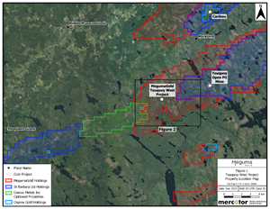
Touquoy West Project Property Location Map
Figure 2
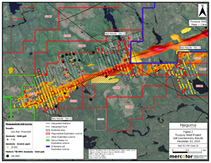
Touquoy West Project Soil Geochemistry Results December 13, 2019
