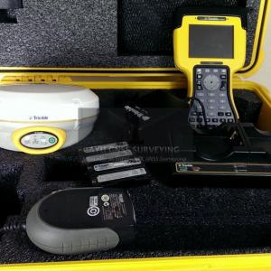
Trimble R4 GPS GNSS RTK Receiver now available at ayugnss.com
Trimble R4 GPS GNSS RTK Receiver is Designed for surveyors looking for easy-to-use GNSS technology that performs under even the most rigorous conditions.
Trimble R4 GPS GNSS RTK Receiver is Designed for surveyors looking for easy-to-use GNSS technology that performs under even the most rigorous conditions.
SINGAPORE, SINGAPORE, SINGAPORE, December 16, 2014 /EINPresswire.com/ -- Trimble R4 GPS GNSS RTK Receiver is Designed for surveyors looking for easy-to-use GNSS technology that performs under even the most rigorous conditions.— Rahayu
Features
220-channel system with Trimble R-Track satellite tracking technology.
Scalable from post processing to VRS to multi-constellation RTK configurations
The flexibility to choose the level of GNSS support that is perfect for your application.
Everything you need to perform a basic survey campaign
Pair with Trimble Access and the new Trimble Slate Controller for a dedicated GNSS solution that is effective for both real time and post processed GNSS surveys
A Complete GNSS System
Lightweight, convenient and cable free
Dual-frequency antenna enhances tracking capacity
Delivers sub-millimeter phase center stability
Internally powered with removable batteries
Comes standard with GPS L1, L2, L2C and QZSS
Choose the level of GNSS support you require with flexible upgrade options including GLONASS , Galileo and BeiDou (COMPASS)
Trimble R4 GPS GNSS RTK Receiver Includes:
Trimble R4 GPS+GLONASS, RTK Receiver with internal 450-470 Mhz
Trimble TSC2 with Survey Controller 12.50
Trimble dual slot charger
TSC2 clamp
UHF radio antenna
Two batteries
Trimble hard transport case
Advanced Trimble R-Track Technology
Integrated in to the Trimble R6, Trimble R-Track technology delivers:
Reliable, precise positioning performance
Signal Prediction compensates for intermittent or marginal RTK correction signals
CMRx communications protocol provides correction compression for optimized bandwidth and full utilization of all the satellites in view
Functions as a VRS Rover, RTK Rover or Field Base Station
Use as a lightweight rover for static surveying or RTK
Compatible with Trimble VRS solutions
Built-in 450 MHZ receive only radio or a fully integrated GSM/GPRS radio
Integrated UHF transmit option
A Complete GNSS System
Lightweight, convenient and cable-free, the Trimble R4 GPS GNSS RTK Receiver with Trimble Access field software provides the ease of use of an integrated receiver and everything you need to perform a basic survey campaign. The dual-frequency antenna enhances tracking capacity and delivers sub-millimeter phase center stability for precise results in demanding conditions. Internally powered with removable batteries, this system provides a full working day of uninterrupted field operation.
Advanced Trimble R-Track Technology
Trimble R4 GPS GNSS RTK Receiver, powered with a Trimble Maxwell 6 chip with 220 channels, delivers the accuracy and reliability required for precision surveying with superior tracking and RTK performance. With GPS L2C and the Japanese QZSS support included, you can track more satellites and measure more successfully in challenging environments. L2C provides more than just additional signals – the advanced signal structure provides better strength for more reliable satellite tracking. Trimble R-Track satellite tracking technology delivers reliable, precise positioning performance. Trimble R-Track with Signal Prediction compensates for intermittent or marginal RTK correction signals, enabling extended precision operation after an RTK signal is interrupted. The CMRx communications protocol provides correction compression for optimized bandwidth and full utilization all of the satellites in view, giving you reliable positioning performance.
Choose The Level Of GNSS Support You Require Today
Choose the level of GNSS support you require today with the flexible upgrade options available on the Trimble R4 GPS GNSS RTK Receiver. Founded on proven GNSS technology, the Trimble R4 comes standard with GPS L1, L2, L2C and QZSS. Beyond this standard GNSS support, the Trimble R4 offers upgrades to GLONASS, Galileo, and BeiDou (COMPASS)—just choose what you need.
Functions As A VRS Rover, RTK Rover, Or Field Base Station
Use as a lightweight rover for static surveying or RTK. Trimble R4 GPS GNSS RTK Receiver is also completely compatible with Trimble VRS solutions, creating a VRS rover for use inside real-time networks. With a built-in 450 MHz receive-only radio or a fully integrated GSM/GPRS radio, this system can be adapted to meet a variety of needs. As a base station, the Trimble R4 with the integrated UHF transmit option is rugged, weather-resistant and compatible with a range of radio solutions.
A Dedicate D, Reliable GNSS Field Solution
Pair the Trimble R4 with Trimble Access and the Trimble Slate Controller1 for a dedicated GNSS solution that is effective for both real time and postprocessed GNSS surveys. Powerful, connected, and compact, the Trimble Slate Controller combines the convenience and ease-ofuse of a smartphone with the durability for which Trimble is known. Its slim, ergonomic design is easy to grasp and its screen provides superior sunlight readability enabling all-day use by hard-working survey professionals. Trimble Access field software provides specialized and customized workflows to make surveying tasks quicker and easier while enabling teams to communicate vital information between field and office in real-time. Survey companies can also implement their unique workflows by taking advantage of the customization capabilities available in the Trimble Access Software Development Kit (SDK). Need to get data back to the office immediately? Benefit from real-time data sharing via Trimble Access Services, now available with any valid Trimble Access maintenance agreement. Back in the office, users can seamlessly process data with Trimble Business Center office software. The Trimble R4 GPS GNSS RTK Receiver– ready and reliable for your everyday surveying needs.
About AYU GNSS SURVEYING
AYU GNSS SURVEYING's legacy began in the early 2000s with a small, dedicated group of geomatics engineers driven by the exciting possibilities of an emerging technology. Since then it has evolved into a global leader in GNSS surveying with over 550 employees and the industry's most comprehensive line of Global Navigation Satellite System (GNSS) products. AYU GNSS SURVEYING now provides its GNSS receivers, antennas and subsystems to developers.
Rahayu
Ayu Gnss Surveying
652227711
email us here

